You are here: Home > Network List > CI - Caltech Regional Seismic Network Stations List
> Station FUR Furnace Creek, CA, USA > Earthquake Result Viewer
FUR Furnace Creek, CA, USA - Earthquake Result Viewer
| Earthquake location: |
Kermadec Islands Region |
| Earthquake latitude/longitude: |
-29.0/-176.2 |
| Earthquake time(UTC): |
2011/10/21 (294) 17:57:16 GMT |
| Earthquake Depth: |
33 km |
| Earthquake Magnitude: |
6.4 MB, 7.5 MS, 7.4 MW, 7.4 MW |
| Earthquake Catalog/Contributor: |
WHDF/NEIC |
|
| Network: |
CI Caltech Regional Seismic Network |
| Station: |
FUR Furnace Creek, CA, USA |
| Lat/Lon: |
36.47 N/116.86 W |
| Elevation: |
-37.0 m |
|
| Distance: |
85.7 deg |
| Az: |
44.074 deg |
| Baz: |
229.109 deg |
| Ray Param: |
0.044509005 |
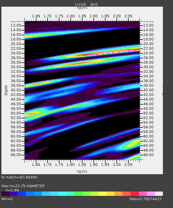
| Estimated Moho Depth: |
23.25 km |
| Estimated Crust Vp/Vs: |
1.98 |
| Assumed Crust Vp: |
6.279 km/s |
| Estimated Crust Vs: |
3.171 km/s |
| Estimated Crust Poisson's Ratio: |
0.33 |
|
| Radial Match: |
93.98495 % |
| Radial Bump: |
400 |
| Transverse Match: |
85.94284 % |
| Transverse Bump: |
400 |
| SOD ConfigId: |
424168 |
| Insert Time: |
2012-02-10 02:17:25.714 +0000 |
| GWidth: |
2.5 |
| Max Bumps: |
400 |
| Tol: |
0.001 |
|
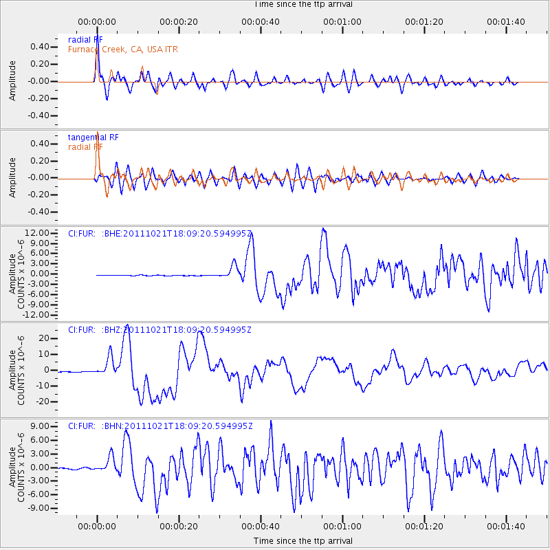
Signal To Noise
| Channel | StoN | STA | LTA |
| CI:FUR: :BHZ:20111021T18:09:20.594995Z | 49.068325 | 6.25637E-6 | 1.2750323E-7 |
| CI:FUR: :BHN:20111021T18:09:20.594995Z | 13.48372 | 1.8122477E-6 | 1.3440265E-7 |
| CI:FUR: :BHE:20111021T18:09:20.594995Z | 21.954315 | 2.0155987E-6 | 9.180878E-8 |
| Arrivals |
| Ps | 3.7 SECOND |
| PpPs | 11 SECOND |
| PsPs/PpSs | 15 SECOND |


