You are here: Home > Network List > G - GEOSCOPE Stations List
> Station GRC Garchy, France > Earthquake Result Viewer
GRC Garchy, France - Earthquake Result Viewer

| Earthquake location: |
Bonin Islands, Japan Region |
| Earthquake latitude/longitude: |
28.9/139.6 |
| Earthquake time(UTC): |
2000/08/06 (219) 07:27:12 GMT |
| Earthquake Depth: |
395 km |
| Earthquake Magnitude: |
6.3 MB, 7.3 MW, 7.3 MW |
| Earthquake Catalog/Contributor: |
WHDF/NEIC |
|
| Network: |
G GEOSCOPE |
| Station: |
GRC Garchy, France |
| Lat/Lon: |
47.30 N/3.07 E |
| Elevation: |
191 m |
|
| Distance: |
94.7 deg |
| Az: |
331.949 deg |
| Baz: |
37.303 deg |
| Ray Param: |
0.0406371 |
| Estimated Moho Depth: |
30.75 km |
| Estimated Crust Vp/Vs: |
1.79 |
| Assumed Crust Vp: |
6.182 km/s |
| Estimated Crust Vs: |
3.463 km/s |
| Estimated Crust Poisson's Ratio: |
0.27 |
|
| Radial Match: |
95.62402 % |
| Radial Bump: |
365 |
| Transverse Match: |
91.564674 % |
| Transverse Bump: |
400 |
| SOD ConfigId: |
3744 |
| Insert Time: |
2010-02-26 22:36:02.035 +0000 |
| GWidth: |
2.5 |
| Max Bumps: |
400 |
| Tol: |
0.001 |
|
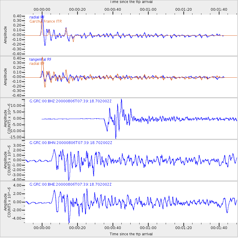
Signal To Noise
| Channel | StoN | STA | LTA |
| G:GRC:00:BHN:20000806T07:39:18.702002Z | 0.8691053 | 1.0957539E-7 | 1.2607838E-7 |
| G:GRC:00:BHE:20000806T07:39:18.702002Z | 0.8212142 | 8.580026E-8 | 1.0447975E-7 |
| G:GRC:00:BHZ:20000806T07:39:18.702002Z | 1.6743346 | 1.6803706E-7 | 1.003605E-7 |
| Arrivals |
| Ps | 4.0 SECOND |
| PpPs | 14 SECOND |
| PsPs/PpSs | 18 SECOND |


