You are here: Home > Network List > CI - Caltech Regional Seismic Network Stations List
> Station SDD Saddleback, Mission Viejo, CA, USA > Earthquake Result Viewer
SDD Saddleback, Mission Viejo, CA, USA - Earthquake Result Viewer
| Earthquake location: |
Kermadec Islands Region |
| Earthquake latitude/longitude: |
-29.0/-176.2 |
| Earthquake time(UTC): |
2011/10/21 (294) 17:57:16 GMT |
| Earthquake Depth: |
33 km |
| Earthquake Magnitude: |
6.4 MB, 7.5 MS, 7.4 MW, 7.4 MW |
| Earthquake Catalog/Contributor: |
WHDF/NEIC |
|
| Network: |
CI Caltech Regional Seismic Network |
| Station: |
SDD Saddleback, Mission Viejo, CA, USA |
| Lat/Lon: |
33.55 N/117.66 W |
| Elevation: |
120 m |
|
| Distance: |
83.3 deg |
| Az: |
45.845 deg |
| Baz: |
228.821 deg |
| Ray Param: |
0.046220493 |
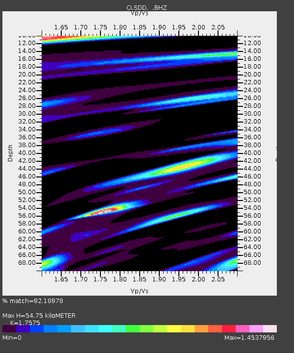
| Estimated Moho Depth: |
54.75 km |
| Estimated Crust Vp/Vs: |
1.76 |
| Assumed Crust Vp: |
6.264 km/s |
| Estimated Crust Vs: |
3.564 km/s |
| Estimated Crust Poisson's Ratio: |
0.26 |
|
| Radial Match: |
92.18978 % |
| Radial Bump: |
400 |
| Transverse Match: |
92.82616 % |
| Transverse Bump: |
400 |
| SOD ConfigId: |
424168 |
| Insert Time: |
2012-02-10 02:18:31.217 +0000 |
| GWidth: |
2.5 |
| Max Bumps: |
400 |
| Tol: |
0.001 |
|

Signal To Noise
| Channel | StoN | STA | LTA |
| CI:SDD: :BHZ:20111021T18:09:08.519983Z | 12.666679 | 8.864596E-6 | 6.998358E-7 |
| CI:SDD: :BHN:20111021T18:09:08.519983Z | 3.4958372 | 2.2036438E-6 | 6.3036225E-7 |
| CI:SDD: :BHE:20111021T18:09:08.519983Z | 5.7167716 | 3.4162465E-6 | 5.9758315E-7 |
| Arrivals |
| Ps | 6.8 SECOND |
| PpPs | 24 SECOND |
| PsPs/PpSs | 30 SECOND |


