You are here: Home > Network List > CI - Caltech Regional Seismic Network Stations List
> Station ADO Adelanto Receiving Station, Victorville, CA, USA > Earthquake Result Viewer
ADO Adelanto Receiving Station, Victorville, CA, USA - Earthquake Result Viewer
| Earthquake location: |
Kermadec Islands Region |
| Earthquake latitude/longitude: |
-29.0/-176.2 |
| Earthquake time(UTC): |
2011/10/21 (294) 17:57:16 GMT |
| Earthquake Depth: |
33 km |
| Earthquake Magnitude: |
6.4 MB, 7.5 MS, 7.4 MW, 7.4 MW |
| Earthquake Catalog/Contributor: |
WHDF/NEIC |
|
| Network: |
CI Caltech Regional Seismic Network |
| Station: |
ADO Adelanto Receiving Station, Victorville, CA, USA |
| Lat/Lon: |
34.55 N/117.43 W |
| Elevation: |
908 m |
|
| Distance: |
84.1 deg |
| Az: |
45.216 deg |
| Baz: |
228.88 deg |
| Ray Param: |
0.04565806 |
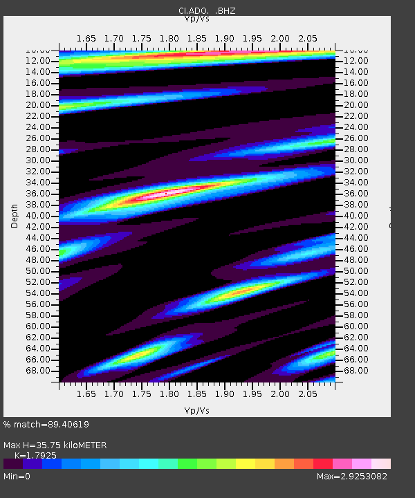
| Estimated Moho Depth: |
35.75 km |
| Estimated Crust Vp/Vs: |
1.79 |
| Assumed Crust Vp: |
6.276 km/s |
| Estimated Crust Vs: |
3.501 km/s |
| Estimated Crust Poisson's Ratio: |
0.27 |
|
| Radial Match: |
89.40619 % |
| Radial Bump: |
400 |
| Transverse Match: |
89.75105 % |
| Transverse Bump: |
400 |
| SOD ConfigId: |
424168 |
| Insert Time: |
2012-02-10 02:19:22.529 +0000 |
| GWidth: |
2.5 |
| Max Bumps: |
400 |
| Tol: |
0.001 |
|

Signal To Noise
| Channel | StoN | STA | LTA |
| CI:ADO: :BHZ:20111021T18:09:12.569971Z | 18.773457 | 7.3333185E-6 | 3.9062166E-7 |
| CI:ADO: :BHN:20111021T18:09:12.569971Z | 3.1954598 | 1.4684443E-6 | 4.5954084E-7 |
| CI:ADO: :BHE:20111021T18:09:12.569971Z | 5.935192 | 2.2136792E-6 | 3.7297517E-7 |
| Arrivals |
| Ps | 4.6 SECOND |
| PpPs | 16 SECOND |
| PsPs/PpSs | 20 SECOND |


