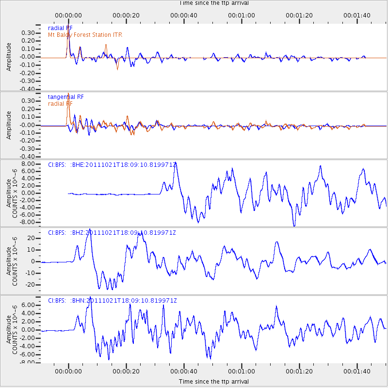
BFS Mt Baldy Forest Station - Earthquake Result Viewer
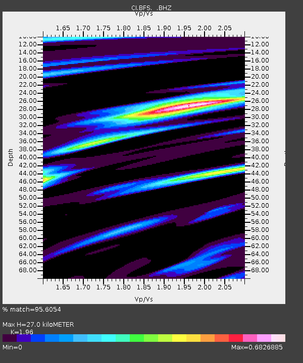
Earthquake location: Kermadec Islands Region
Earthquake latitude/longitude: -29.0/-176.2
Earthquake time(UTC): 2011/10/21 (294) 17:57:16 GMT
Earthquake Depth: 33 km
Earthquake Magnitude: 6.4 MB, 7.5 MS, 7.4 MW, 7.4 MW
Earthquake Catalog/Contributor: WHDF/NEIC
Network: CI Caltech Regional Seismic Network
Station: BFS Mt Baldy Forest Station
Lat/Lon: 34.24 N/117.66 W
Elevation: 1312 m
Distance: 83.8 deg
Az: 45.329 deg
Baz: 228.765 deg
Ray Param: 0.045897942
Estimated Moho Depth: 27.0 km
Estimated Crust Vp/Vs: 1.96
Assumed Crust Vp: 6.276 km/s
Estimated Crust Vs: 3.202 km/s
Estimated Crust Poisson's Ratio: 0.32
Radial Match: 95.6054 %
Radial Bump: 400
Transverse Match: 84.44279 %
Transverse Bump: 400
SOD ConfigId: 424168
Insert Time: 2012-02-10 02:20:15.336 +0000
GWidth: 2.5
Max Bumps: 400
Tol: 0.001

Signal To Noise

ChannelStoNSTALTA
CI:BFS: :BHZ:20111021T18:09:10.819971Z40.2367675.8549185E-61.4551165E-7
CI:BFS: :BHN:20111021T18:09:10.819971Z13.7717551.5692684E-61.13948325E-7
CI:BFS: :BHE:20111021T18:09:10.819971Z15.1912941.4753706E-69.711949E-8
Arrivals
Ps4.2 SECOND
PpPs12 SECOND
PsPs/PpSs17 SECOND