You are here: Home > Network List > G - GEOSCOPE Stations List
> Station UNM Unam,Mexico > Earthquake Result Viewer
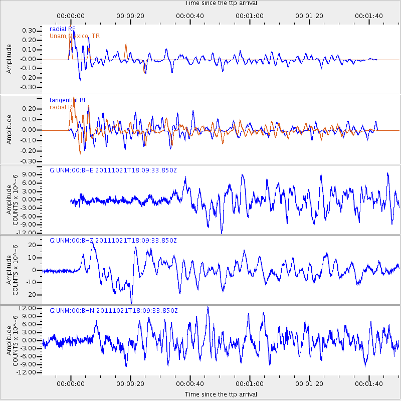
UNM Unam,Mexico - Earthquake Result Viewer
*The percent match for this event was below the threshold and hence no stack was calculated.
| Earthquake location: |
Kermadec Islands Region |
| Earthquake latitude/longitude: |
-29.0/-176.2 |
| Earthquake time(UTC): |
2011/10/21 (294) 17:57:16 GMT |
| Earthquake Depth: |
33 km |
| Earthquake Magnitude: |
6.4 MB, 7.5 MS, 7.4 MW, 7.4 MW |
| Earthquake Catalog/Contributor: |
WHDF/NEIC |
|
| Network: |
G GEOSCOPE |
| Station: |
UNM Unam,Mexico |
| Lat/Lon: |
19.33 N/99.18 W |
| Elevation: |
2280 m |
|
| Distance: |
88.5 deg |
| Az: |
67.024 deg |
| Baz: |
238.661 deg |
| Ray Param: |
$rayparam |
*The percent match for this event was below the threshold and hence was not used in the summary stack. |
|
| Radial Match: |
90.9465 % |
| Radial Bump: |
400 |
| Transverse Match: |
87.98453 % |
| Transverse Bump: |
400 |
| SOD ConfigId: |
424168 |
| Insert Time: |
2012-02-10 02:22:02.508 +0000 |
| GWidth: |
2.5 |
| Max Bumps: |
400 |
| Tol: |
0.001 |
|
Signal To Noise
| Channel | StoN | STA | LTA |
| G:UNM:00:BHZ:20111021T18:09:33.850Z | 7.197975 | 4.850446E-6 | 6.7386253E-7 |
| G:UNM:00:BHN:20111021T18:09:33.850Z | 0.87987137 | 8.5996095E-7 | 9.773712E-7 |
| G:UNM:00:BHE:20111021T18:09:33.850Z | 1.5287113 | 1.256566E-6 | 8.219772E-7 |
| Arrivals |
| Ps | |
| PpPs | |
| PsPs/PpSs | |


