You are here: Home > Network List > G - GEOSCOPE Stations List
> Station GRC Garchy, France > Earthquake Result Viewer
GRC Garchy, France - Earthquake Result Viewer

| Earthquake location: |
Near Coast Of Peru |
| Earthquake latitude/longitude: |
-16.3/-73.6 |
| Earthquake time(UTC): |
2001/06/23 (174) 20:33:14 GMT |
| Earthquake Depth: |
33 km |
| Earthquake Magnitude: |
6.7 MB, 8.2 MS, 8.4 MW, 7.8 ME |
| Earthquake Catalog/Contributor: |
WHDF/NEIC |
|
| Network: |
G GEOSCOPE |
| Station: |
GRC Garchy, France |
| Lat/Lon: |
47.30 N/3.07 E |
| Elevation: |
191 m |
|
| Distance: |
93.1 deg |
| Az: |
41.561 deg |
| Baz: |
249.411 deg |
| Ray Param: |
0.0413212 |
| Estimated Moho Depth: |
29.75 km |
| Estimated Crust Vp/Vs: |
1.71 |
| Assumed Crust Vp: |
6.182 km/s |
| Estimated Crust Vs: |
3.61 km/s |
| Estimated Crust Poisson's Ratio: |
0.24 |
|
| Radial Match: |
96.87521 % |
| Radial Bump: |
343 |
| Transverse Match: |
97.91352 % |
| Transverse Bump: |
357 |
| SOD ConfigId: |
4714 |
| Insert Time: |
2010-02-26 22:36:08.828 +0000 |
| GWidth: |
2.5 |
| Max Bumps: |
400 |
| Tol: |
0.001 |
|
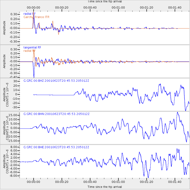
Signal To Noise
| Channel | StoN | STA | LTA |
| G:GRC:00:BHN:20010623T20:45:53.205012Z | 17.941109 | 2.0389857E-6 | 1.1364882E-7 |
| G:GRC:00:BHE:20010623T20:45:53.205012Z | 8.290432 | 6.921465E-7 | 8.3487386E-8 |
| G:GRC:00:BHZ:20010623T20:45:53.205012Z | 20.845425 | 6.1521005E-6 | 2.9512952E-7 |
| Arrivals |
| Ps | 3.5 SECOND |
| PpPs | 13 SECOND |
| PsPs/PpSs | 16 SECOND |


