You are here: Home > Network List > IU - Global Seismograph Network (GSN - IRIS/USGS) Stations List
> Station PTCN Pitcairn Island, South Pacific > Earthquake Result Viewer
PTCN Pitcairn Island, South Pacific - Earthquake Result Viewer

| Earthquake location: |
Kermadec Islands Region |
| Earthquake latitude/longitude: |
-29.0/-176.2 |
| Earthquake time(UTC): |
2011/10/21 (294) 17:57:16 GMT |
| Earthquake Depth: |
33 km |
| Earthquake Magnitude: |
6.4 MB, 7.5 MS, 7.4 MW, 7.4 MW |
| Earthquake Catalog/Contributor: |
WHDF/NEIC |
|
| Network: |
IU Global Seismograph Network (GSN - IRIS/USGS) |
| Station: |
PTCN Pitcairn Island, South Pacific |
| Lat/Lon: |
25.07 S/130.10 W |
| Elevation: |
220 m |
|
| Distance: |
41.1 deg |
| Az: |
95.78 deg |
| Baz: |
253.968 deg |
| Ray Param: |
0.07394274 |
| Estimated Moho Depth: |
53.75 km |
| Estimated Crust Vp/Vs: |
1.66 |
| Assumed Crust Vp: |
4.24 km/s |
| Estimated Crust Vs: |
2.547 km/s |
| Estimated Crust Poisson's Ratio: |
0.22 |
|
| Radial Match: |
90.42658 % |
| Radial Bump: |
400 |
| Transverse Match: |
70.9648 % |
| Transverse Bump: |
400 |
| SOD ConfigId: |
424168 |
| Insert Time: |
2012-02-10 02:23:54.872 +0000 |
| GWidth: |
2.5 |
| Max Bumps: |
400 |
| Tol: |
0.001 |
|
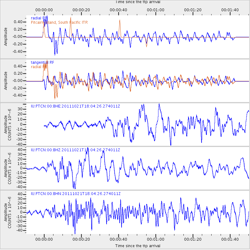
Signal To Noise
| Channel | StoN | STA | LTA |
| IU:PTCN:00:BHZ:20111021T18:04:26.274011Z | 5.7356434 | 8.14653E-6 | 1.420334E-6 |
| IU:PTCN:00:BHN:20111021T18:04:26.274011Z | 2.4758399 | 6.4386845E-6 | 2.600606E-6 |
| IU:PTCN:00:BHE:20111021T18:04:26.274011Z | 1.8888646 | 7.241291E-6 | 3.833674E-6 |
| Arrivals |
| Ps | 8.7 SECOND |
| PpPs | 33 SECOND |
| PsPs/PpSs | 41 SECOND |


