You are here: Home > Network List > IW - Intermountain West Stations List
> Station FXWY Fox Creek, Wyoming, USA > Earthquake Result Viewer
FXWY Fox Creek, Wyoming, USA - Earthquake Result Viewer
| Earthquake location: |
Kermadec Islands Region |
| Earthquake latitude/longitude: |
-29.0/-176.2 |
| Earthquake time(UTC): |
2011/10/21 (294) 17:57:16 GMT |
| Earthquake Depth: |
33 km |
| Earthquake Magnitude: |
6.4 MB, 7.5 MS, 7.4 MW, 7.4 MW |
| Earthquake Catalog/Contributor: |
WHDF/NEIC |
|
| Network: |
IW Intermountain West |
| Station: |
FXWY Fox Creek, Wyoming, USA |
| Lat/Lon: |
43.64 N/111.03 W |
| Elevation: |
2254 m |
|
| Distance: |
93.7 deg |
| Az: |
41.34 deg |
| Baz: |
232.846 deg |
| Ray Param: |
0.041193508 |
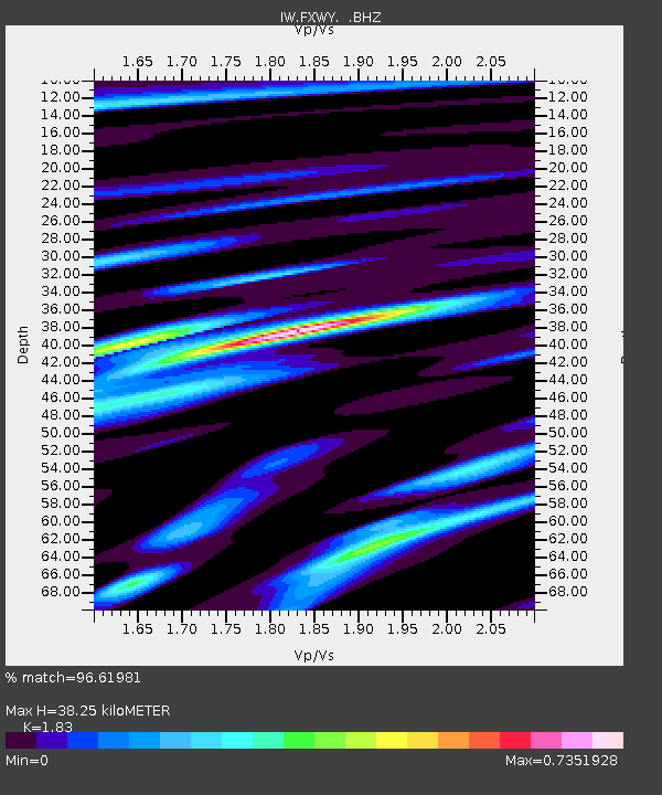
| Estimated Moho Depth: |
38.25 km |
| Estimated Crust Vp/Vs: |
1.83 |
| Assumed Crust Vp: |
6.207 km/s |
| Estimated Crust Vs: |
3.392 km/s |
| Estimated Crust Poisson's Ratio: |
0.29 |
|
| Radial Match: |
96.61981 % |
| Radial Bump: |
400 |
| Transverse Match: |
90.25674 % |
| Transverse Bump: |
400 |
| SOD ConfigId: |
424168 |
| Insert Time: |
2012-02-10 02:25:25.969 +0000 |
| GWidth: |
2.5 |
| Max Bumps: |
400 |
| Tol: |
0.001 |
|
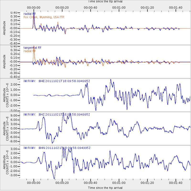
Signal To Noise
| Channel | StoN | STA | LTA |
| IW:FXWY: :BHZ:20111021T18:09:58.094995Z | 34.57033 | 2.0612295E-6 | 5.962423E-8 |
| IW:FXWY: :BHN:20111021T18:09:58.094995Z | 6.390534 | 4.927929E-7 | 7.711294E-8 |
| IW:FXWY: :BHE:20111021T18:09:58.094995Z | 6.486806 | 4.5857468E-7 | 7.0693446E-8 |
| Arrivals |
| Ps | 5.2 SECOND |
| PpPs | 17 SECOND |
| PsPs/PpSs | 22 SECOND |


