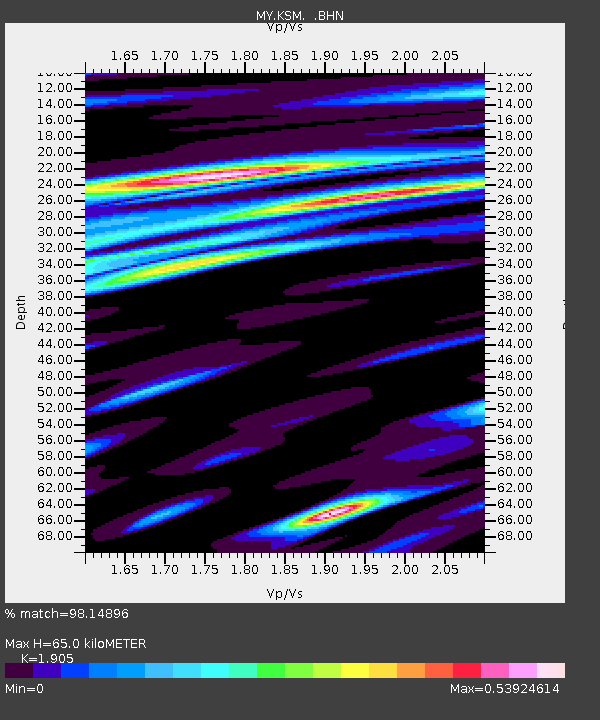
KSM Kuching - Earthquake Result Viewer

Earthquake location: Kermadec Islands Region
Earthquake latitude/longitude: -29.0/-176.2
Earthquake time(UTC): 2011/10/21 (294) 17:57:16 GMT
Earthquake Depth: 33 km
Earthquake Magnitude: 6.4 MB, 7.5 MS, 7.4 MW, 7.4 MW
Earthquake Catalog/Contributor: WHDF/NEIC
Network: MY Malaysian National Seismic Network
Station: KSM Kuching
Lat/Lon: 1.47 N/110.31 E
Elevation: 66 m
Distance: 76.3 deg
Az: 279.459 deg
Baz: 120.183 deg
Ray Param: 0.051050425
Estimated Moho Depth: 65.0 km
Estimated Crust Vp/Vs: 1.90
Assumed Crust Vp: 6.468 km/s
Estimated Crust Vs: 3.395 km/s
Estimated Crust Poisson's Ratio: 0.31
Radial Match: 98.14896 %
Radial Bump: 358
Transverse Match: 93.64078 %
Transverse Bump: 400
SOD ConfigId: 424168
Insert Time: 2012-02-10 02:26:33.377 +0000
GWidth: 2.5
Max Bumps: 400
Tol: 0.001

Signal To Noise

ChannelStoNSTALTA
MY:KSM: :BHZ:20111021T18:08:30.519983Z44.832374.953859E-61.1049736E-7
MY:KSM: :BHN:20111021T18:08:30.519983Z30.8960911.2184995E-63.9438632E-8
MY:KSM: :BHE:20111021T18:08:30.519983Z21.5767941.3123079E-66.082034E-8
Arrivals
Ps9.4 SECOND
PpPs28 SECOND
PsPs/PpSs38 SECOND