You are here: Home > Network List > MY - Malaysian National Seismic Network Stations List
> Station SBM Sibu > Earthquake Result Viewer
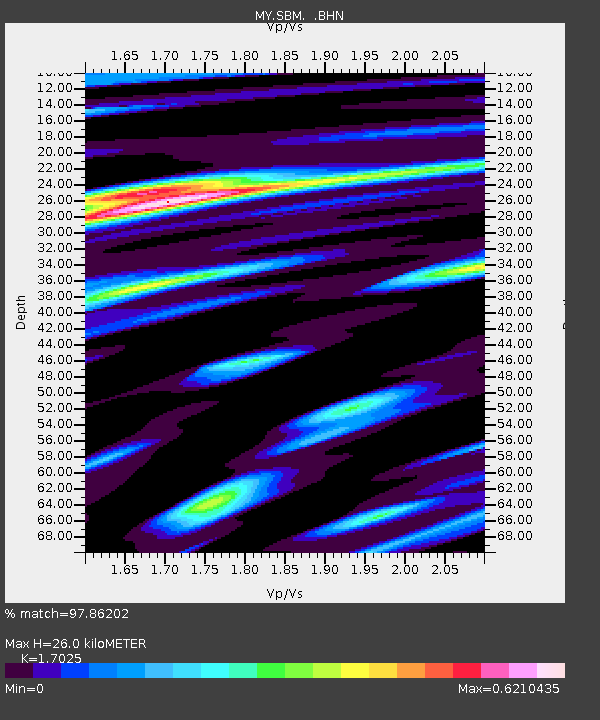
SBM Sibu - Earthquake Result Viewer
| Earthquake location: |
Kermadec Islands Region |
| Earthquake latitude/longitude: |
-29.0/-176.2 |
| Earthquake time(UTC): |
2011/10/21 (294) 17:57:16 GMT |
| Earthquake Depth: |
33 km |
| Earthquake Magnitude: |
6.4 MB, 7.5 MS, 7.4 MW, 7.4 MW |
| Earthquake Catalog/Contributor: |
WHDF/NEIC |
|
| Network: |
MY Malaysian National Seismic Network |
| Station: |
SBM Sibu |
| Lat/Lon: |
2.45 N/112.21 E |
| Elevation: |
237 m |
|
| Distance: |
75.1 deg |
| Az: |
281.321 deg |
| Baz: |
120.707 deg |
| Ray Param: |
0.051823445 |
| Estimated Moho Depth: |
26.0 km |
| Estimated Crust Vp/Vs: |
1.70 |
| Assumed Crust Vp: |
6.343 km/s |
| Estimated Crust Vs: |
3.726 km/s |
| Estimated Crust Poisson's Ratio: |
0.24 |
|
| Radial Match: |
97.86202 % |
| Radial Bump: |
397 |
| Transverse Match: |
92.37691 % |
| Transverse Bump: |
400 |
| SOD ConfigId: |
424168 |
| Insert Time: |
2012-02-10 02:26:39.207 +0000 |
| GWidth: |
2.5 |
| Max Bumps: |
400 |
| Tol: |
0.001 |
|

Signal To Noise
| Channel | StoN | STA | LTA |
| MY:SBM: :BHZ:20111021T18:08:23.969995Z | 52.662586 | 5.123707E-6 | 9.729312E-8 |
| MY:SBM: :BHN:20111021T18:08:23.969995Z | 18.544971 | 9.266377E-7 | 4.9967063E-8 |
| MY:SBM: :BHE:20111021T18:08:23.969995Z | 32.0052 | 1.583929E-6 | 4.948974E-8 |
| Arrivals |
| Ps | 3.0 SECOND |
| PpPs | 11 SECOND |
| PsPs/PpSs | 14 SECOND |


