You are here: Home > Network List > PS - Pacific21 Stations List
> Station PATS 6onpei, Micronesia > Earthquake Result Viewer
PATS 6onpei, Micronesia - Earthquake Result Viewer
| Earthquake location: |
Kermadec Islands Region |
| Earthquake latitude/longitude: |
-29.0/-176.2 |
| Earthquake time(UTC): |
2011/10/21 (294) 17:57:16 GMT |
| Earthquake Depth: |
33 km |
| Earthquake Magnitude: |
6.4 MB, 7.5 MS, 7.4 MW, 7.4 MW |
| Earthquake Catalog/Contributor: |
WHDF/NEIC |
|
| Network: |
PS Pacific21 |
| Station: |
PATS 6onpei, Micronesia |
| Lat/Lon: |
6.84 N/158.32 E |
| Elevation: |
10 m |
|
| Distance: |
43.2 deg |
| Az: |
321.479 deg |
| Baz: |
146.67 deg |
| Ray Param: |
0.07261205 |
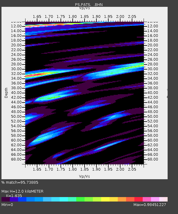
| Estimated Moho Depth: |
12.0 km |
| Estimated Crust Vp/Vs: |
1.63 |
| Assumed Crust Vp: |
4.24 km/s |
| Estimated Crust Vs: |
2.593 km/s |
| Estimated Crust Poisson's Ratio: |
0.20 |
|
| Radial Match: |
95.73885 % |
| Radial Bump: |
323 |
| Transverse Match: |
76.76406 % |
| Transverse Bump: |
400 |
| SOD ConfigId: |
424168 |
| Insert Time: |
2012-02-10 02:27:48.528 +0000 |
| GWidth: |
2.5 |
| Max Bumps: |
400 |
| Tol: |
0.001 |
|

Signal To Noise
| Channel | StoN | STA | LTA |
| PS:PATS: :BHZ:20111021T18:04:43.761011Z | 5.245134 | 4.3965365E-6 | 8.382125E-7 |
| PS:PATS: :BHN:20111021T18:04:43.761011Z | 3.718201 | 2.7517915E-6 | 7.400868E-7 |
| PS:PATS: :BHE:20111021T18:04:43.761011Z | 3.0360184 | 2.013336E-6 | 6.631501E-7 |
| Arrivals |
| Ps | 1.9 SECOND |
| PpPs | 7.2 SECOND |
| PsPs/PpSs | 9.1 SECOND |


