You are here: Home > Network List > TA - USArray Transportable Network (new EarthScope stations) Stations List
> Station Y12C Blythe, CA, USA > Earthquake Result Viewer
Y12C Blythe, CA, USA - Earthquake Result Viewer

| Earthquake location: |
Kermadec Islands Region |
| Earthquake latitude/longitude: |
-29.0/-176.2 |
| Earthquake time(UTC): |
2011/10/21 (294) 17:57:16 GMT |
| Earthquake Depth: |
33 km |
| Earthquake Magnitude: |
6.4 MB, 7.5 MS, 7.4 MW, 7.4 MW |
| Earthquake Catalog/Contributor: |
WHDF/NEIC |
|
| Network: |
TA USArray Transportable Network (new EarthScope stations) |
| Station: |
Y12C Blythe, CA, USA |
| Lat/Lon: |
33.75 N/114.52 W |
| Elevation: |
196 m |
|
| Distance: |
85.5 deg |
| Az: |
47.393 deg |
| Baz: |
230.704 deg |
| Ray Param: |
0.04470818 |
| Estimated Moho Depth: |
23.0 km |
| Estimated Crust Vp/Vs: |
1.93 |
| Assumed Crust Vp: |
6.155 km/s |
| Estimated Crust Vs: |
3.193 km/s |
| Estimated Crust Poisson's Ratio: |
0.32 |
|
| Radial Match: |
97.80781 % |
| Radial Bump: |
384 |
| Transverse Match: |
89.891754 % |
| Transverse Bump: |
400 |
| SOD ConfigId: |
424168 |
| Insert Time: |
2012-02-10 02:28:27.540 +0000 |
| GWidth: |
2.5 |
| Max Bumps: |
400 |
| Tol: |
0.001 |
|
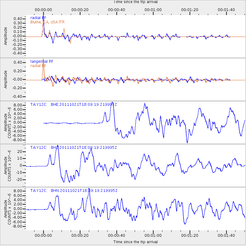
Signal To Noise
| Channel | StoN | STA | LTA |
| TA:Y12C: :BHZ:20111021T18:09:19.219995Z | 38.13384 | 6.435202E-6 | 1.6875305E-7 |
| TA:Y12C: :BHN:20111021T18:09:19.219995Z | 22.55032 | 1.3783871E-6 | 6.112494E-8 |
| TA:Y12C: :BHE:20111021T18:09:19.219995Z | 17.260105 | 1.9716333E-6 | 1.1423066E-7 |
| Arrivals |
| Ps | 3.5 SECOND |
| PpPs | 11 SECOND |
| PsPs/PpSs | 14 SECOND |


