You are here: Home > Network List > G - GEOSCOPE Stations List
> Station HDC Heredia, Costa Rica > Earthquake Result Viewer
HDC Heredia, Costa Rica - Earthquake Result Viewer
| Earthquake location: |
Chile-Argentina Border Region |
| Earthquake latitude/longitude: |
-33.9/-70.1 |
| Earthquake time(UTC): |
2000/06/16 (168) 07:55:35 GMT |
| Earthquake Depth: |
120 km |
| Earthquake Magnitude: |
6.2 MB, 6.5 MW, 6.1 MD |
| Earthquake Catalog/Contributor: |
WHDF/NEIC |
|
| Network: |
G GEOSCOPE |
| Station: |
HDC Heredia, Costa Rica |
| Lat/Lon: |
10.00 N/84.11 W |
| Elevation: |
1150 m |
|
| Distance: |
45.6 deg |
| Az: |
340.492 deg |
| Baz: |
163.617 deg |
| Ray Param: |
0.07073986 |
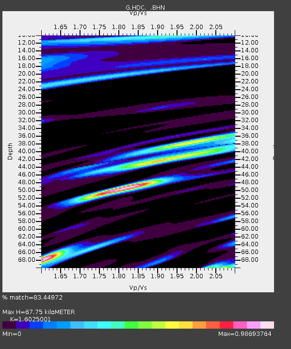
| Estimated Moho Depth: |
67.75 km |
| Estimated Crust Vp/Vs: |
1.60 |
| Assumed Crust Vp: |
6.597 km/s |
| Estimated Crust Vs: |
4.117 km/s |
| Estimated Crust Poisson's Ratio: |
0.18 |
|
| Radial Match: |
83.44972 % |
| Radial Bump: |
400 |
| Transverse Match: |
87.25535 % |
| Transverse Bump: |
400 |
| SOD ConfigId: |
3744 |
| Insert Time: |
2010-02-26 22:36:15.632 +0000 |
| GWidth: |
2.5 |
| Max Bumps: |
400 |
| Tol: |
0.001 |
|

Signal To Noise
| Channel | StoN | STA | LTA |
| G:HDC: :BHN:20000616T08:03:13.249009Z | 7.4469976 | 1.948352E-6 | 2.616292E-7 |
| G:HDC: :BHE:20000616T08:03:13.249009Z | 2.9329116 | 9.400115E-7 | 3.2050454E-7 |
| G:HDC: :BHZ:20000616T08:03:13.249009Z | 31.316826 | 8.550413E-6 | 2.7302937E-7 |
| Arrivals |
| Ps | 6.7 SECOND |
| PpPs | 25 SECOND |
| PsPs/PpSs | 31 SECOND |


