You are here: Home > Network List > TA - USArray Transportable Network (new EarthScope stations) Stations List
> Station G05D Wamic, OR, USA > Earthquake Result Viewer
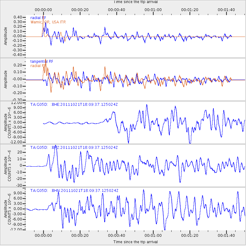
G05D Wamic, OR, USA - Earthquake Result Viewer
*The percent match for this event was below the threshold and hence no stack was calculated.
| Earthquake location: |
Kermadec Islands Region |
| Earthquake latitude/longitude: |
-29.0/-176.2 |
| Earthquake time(UTC): |
2011/10/21 (294) 17:57:16 GMT |
| Earthquake Depth: |
33 km |
| Earthquake Magnitude: |
6.4 MB, 7.5 MS, 7.4 MW, 7.4 MW |
| Earthquake Catalog/Contributor: |
WHDF/NEIC |
|
| Network: |
TA USArray Transportable Network (new EarthScope stations) |
| Station: |
G05D Wamic, OR, USA |
| Lat/Lon: |
45.24 N/121.32 W |
| Elevation: |
592 m |
|
| Distance: |
89.2 deg |
| Az: |
35.326 deg |
| Baz: |
225.808 deg |
| Ray Param: |
$rayparam |
*The percent match for this event was below the threshold and hence was not used in the summary stack. |
|
| Radial Match: |
88.611626 % |
| Radial Bump: |
400 |
| Transverse Match: |
81.23748 % |
| Transverse Bump: |
400 |
| SOD ConfigId: |
424168 |
| Insert Time: |
2012-02-10 02:30:56.405 +0000 |
| GWidth: |
2.5 |
| Max Bumps: |
400 |
| Tol: |
0.001 |
|
Signal To Noise
| Channel | StoN | STA | LTA |
| TA:G05D: :BHZ:20111021T18:09:37.125024Z | 25.289528 | 6.897349E-6 | 2.7273538E-7 |
| TA:G05D: :BHN:20111021T18:09:37.125024Z | 5.253096 | 1.6382243E-6 | 3.118588E-7 |
| TA:G05D: :BHE:20111021T18:09:37.125024Z | 3.1664817 | 1.1452064E-6 | 3.6166526E-7 |
| Arrivals |
| Ps | |
| PpPs | |
| PsPs/PpSs | |


