You are here: Home > Network List > TA - USArray Transportable Network (new EarthScope stations) Stations List
> Station 437A Phaontom Ranch, North Zulch, TX, USA > Earthquake Result Viewer
437A Phaontom Ranch, North Zulch, TX, USA - Earthquake Result Viewer
| Earthquake location: |
Kermadec Islands Region |
| Earthquake latitude/longitude: |
-29.0/-176.2 |
| Earthquake time(UTC): |
2011/10/21 (294) 17:57:16 GMT |
| Earthquake Depth: |
33 km |
| Earthquake Magnitude: |
6.4 MB, 7.5 MS, 7.4 MW, 7.4 MW |
| Earthquake Catalog/Contributor: |
WHDF/NEIC |
|
| Network: |
TA USArray Transportable Network (new EarthScope stations) |
| Station: |
437A Phaontom Ranch, North Zulch, TX, USA |
| Lat/Lon: |
30.83 N/96.14 W |
| Elevation: |
95 m |
|
| Distance: |
96.7 deg |
| Az: |
58.56 deg |
| Baz: |
240.332 deg |
| Ray Param: |
0.040426467 |
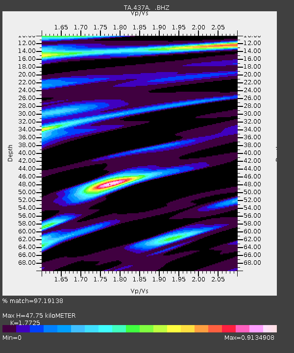
| Estimated Moho Depth: |
47.75 km |
| Estimated Crust Vp/Vs: |
1.77 |
| Assumed Crust Vp: |
6.347 km/s |
| Estimated Crust Vs: |
3.581 km/s |
| Estimated Crust Poisson's Ratio: |
0.27 |
|
| Radial Match: |
97.19138 % |
| Radial Bump: |
391 |
| Transverse Match: |
88.47268 % |
| Transverse Bump: |
400 |
| SOD ConfigId: |
424168 |
| Insert Time: |
2012-02-10 02:33:51.456 +0000 |
| GWidth: |
2.5 |
| Max Bumps: |
400 |
| Tol: |
0.001 |
|

Signal To Noise
| Channel | StoN | STA | LTA |
| TA:437A: :BHZ:20111021T18:10:11.524988Z | 10.444553 | 2.3768023E-6 | 2.2756379E-7 |
| TA:437A: :BHN:20111021T18:10:11.524988Z | 1.1676785 | 7.380165E-7 | 6.320374E-7 |
| TA:437A: :BHE:20111021T18:10:11.524988Z | 1.9966002 | 7.0823575E-7 | 3.5472087E-7 |
| Arrivals |
| Ps | 5.9 SECOND |
| PpPs | 20 SECOND |
| PsPs/PpSs | 26 SECOND |


