You are here: Home > Network List > TA - USArray Transportable Network (new EarthScope stations) Stations List
> Station 237A Washetta, Montalba, TX, USA > Earthquake Result Viewer
237A Washetta, Montalba, TX, USA - Earthquake Result Viewer
| Earthquake location: |
Kermadec Islands Region |
| Earthquake latitude/longitude: |
-29.0/-176.2 |
| Earthquake time(UTC): |
2011/10/21 (294) 17:57:16 GMT |
| Earthquake Depth: |
33 km |
| Earthquake Magnitude: |
6.4 MB, 7.5 MS, 7.4 MW, 7.4 MW |
| Earthquake Catalog/Contributor: |
WHDF/NEIC |
|
| Network: |
TA USArray Transportable Network (new EarthScope stations) |
| Station: |
237A Washetta, Montalba, TX, USA |
| Lat/Lon: |
32.00 N/95.81 W |
| Elevation: |
126 m |
|
| Distance: |
97.5 deg |
| Az: |
57.676 deg |
| Baz: |
240.612 deg |
| Ray Param: |
0.04017877 |
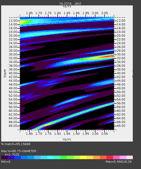
| Estimated Moho Depth: |
68.75 km |
| Estimated Crust Vp/Vs: |
1.70 |
| Assumed Crust Vp: |
6.245 km/s |
| Estimated Crust Vs: |
3.668 km/s |
| Estimated Crust Poisson's Ratio: |
0.24 |
|
| Radial Match: |
95.15669 % |
| Radial Bump: |
361 |
| Transverse Match: |
83.94774 % |
| Transverse Bump: |
400 |
| SOD ConfigId: |
424168 |
| Insert Time: |
2012-02-10 02:34:07.395 +0000 |
| GWidth: |
2.5 |
| Max Bumps: |
400 |
| Tol: |
0.001 |
|

Signal To Noise
| Channel | StoN | STA | LTA |
| TA:237A: :BHZ:20111021T18:10:15.199976Z | 10.306396 | 2.0864506E-6 | 2.0244234E-7 |
| TA:237A: :BHN:20111021T18:10:15.199976Z | 1.7084174 | 4.845069E-7 | 2.8359983E-7 |
| TA:237A: :BHE:20111021T18:10:15.199976Z | 1.9687489 | 6.7518766E-7 | 3.4295263E-7 |
| Arrivals |
| Ps | 7.9 SECOND |
| PpPs | 29 SECOND |
| PsPs/PpSs | 37 SECOND |


