You are here: Home > Network List > TA - USArray Transportable Network (new EarthScope stations) Stations List
> Station Y35A Marietta, OK, USA > Earthquake Result Viewer
Y35A Marietta, OK, USA - Earthquake Result Viewer

| Earthquake location: |
Kermadec Islands Region |
| Earthquake latitude/longitude: |
-29.0/-176.2 |
| Earthquake time(UTC): |
2011/10/21 (294) 17:57:16 GMT |
| Earthquake Depth: |
33 km |
| Earthquake Magnitude: |
6.4 MB, 7.5 MS, 7.4 MW, 7.4 MW |
| Earthquake Catalog/Contributor: |
WHDF/NEIC |
|
| Network: |
TA USArray Transportable Network (new EarthScope stations) |
| Station: |
Y35A Marietta, OK, USA |
| Lat/Lon: |
33.91 N/97.04 W |
| Elevation: |
214 m |
|
| Distance: |
97.5 deg |
| Az: |
55.495 deg |
| Baz: |
240.232 deg |
| Ray Param: |
0.0401671 |
| Estimated Moho Depth: |
49.25 km |
| Estimated Crust Vp/Vs: |
1.74 |
| Assumed Crust Vp: |
6.38 km/s |
| Estimated Crust Vs: |
3.667 km/s |
| Estimated Crust Poisson's Ratio: |
0.25 |
|
| Radial Match: |
96.52031 % |
| Radial Bump: |
361 |
| Transverse Match: |
81.525215 % |
| Transverse Bump: |
400 |
| SOD ConfigId: |
424168 |
| Insert Time: |
2012-02-10 02:35:04.371 +0000 |
| GWidth: |
2.5 |
| Max Bumps: |
400 |
| Tol: |
0.001 |
|
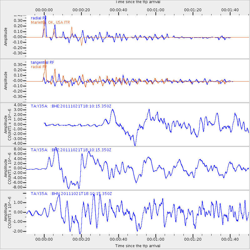
Signal To Noise
| Channel | StoN | STA | LTA |
| TA:Y35A: :BHZ:20111021T18:10:15.350Z | 14.409174 | 2.2595789E-6 | 1.5681529E-7 |
| TA:Y35A: :BHN:20111021T18:10:15.350Z | 2.3097188 | 5.111603E-7 | 2.2130845E-7 |
| TA:Y35A: :BHE:20111021T18:10:15.350Z | 4.8744726 | 6.0544323E-7 | 1.2420692E-7 |
| Arrivals |
| Ps | 5.8 SECOND |
| PpPs | 21 SECOND |
| PsPs/PpSs | 27 SECOND |


