You are here: Home > Network List > TA - USArray Transportable Network (new EarthScope stations) Stations List
> Station E04D Cinebar, WA, USA > Earthquake Result Viewer
E04D Cinebar, WA, USA - Earthquake Result Viewer
| Earthquake location: |
Kermadec Islands Region |
| Earthquake latitude/longitude: |
-29.0/-176.2 |
| Earthquake time(UTC): |
2011/10/21 (294) 17:57:16 GMT |
| Earthquake Depth: |
33 km |
| Earthquake Magnitude: |
6.4 MB, 7.5 MS, 7.4 MW, 7.4 MW |
| Earthquake Catalog/Contributor: |
WHDF/NEIC |
|
| Network: |
TA USArray Transportable Network (new EarthScope stations) |
| Station: |
E04D Cinebar, WA, USA |
| Lat/Lon: |
46.56 N/122.57 W |
| Elevation: |
204 m |
|
| Distance: |
89.5 deg |
| Az: |
33.777 deg |
| Baz: |
224.894 deg |
| Ray Param: |
0.041781574 |
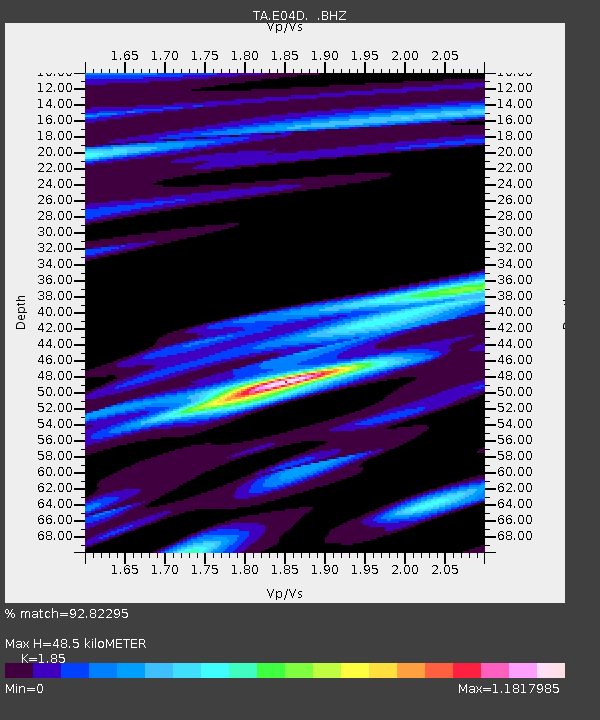
| Estimated Moho Depth: |
48.5 km |
| Estimated Crust Vp/Vs: |
1.85 |
| Assumed Crust Vp: |
6.566 km/s |
| Estimated Crust Vs: |
3.549 km/s |
| Estimated Crust Poisson's Ratio: |
0.29 |
|
| Radial Match: |
92.82295 % |
| Radial Bump: |
400 |
| Transverse Match: |
82.22744 % |
| Transverse Bump: |
400 |
| SOD ConfigId: |
424168 |
| Insert Time: |
2012-02-10 02:37:16.850 +0000 |
| GWidth: |
2.5 |
| Max Bumps: |
400 |
| Tol: |
0.001 |
|
Signal To Noise
| Channel | StoN | STA | LTA |
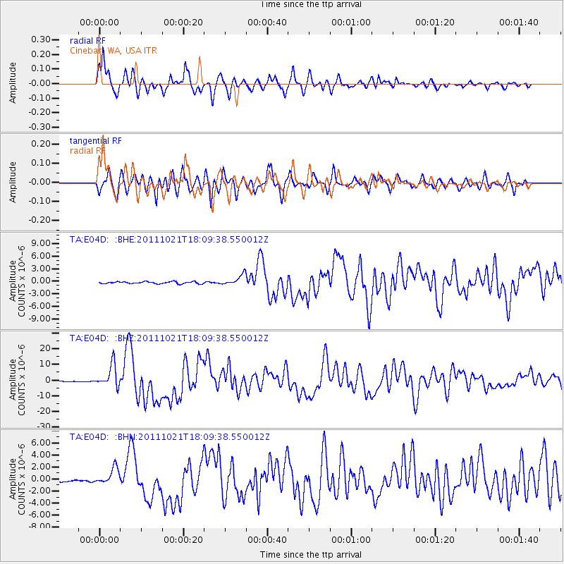
| TA:E04D: :BHZ:20111021T18:09:38.550012Z | 38.80768 | 7.307651E-6 | 1.8830426E-7 |
| TA:E04D: :BHN:20111021T18:09:38.550012Z | 9.891406 | 1.4497228E-6 | 1.4656386E-7 |
| TA:E04D: :BHE:20111021T18:09:38.550012Z | 5.3502674 | 1.2943757E-6 | 2.419273E-7 |
| Arrivals |
| Ps | 6.4 SECOND |
| PpPs | 21 SECOND |
| PsPs/PpSs | 27 SECOND |


