You are here: Home > Network List > G - GEOSCOPE Stations List
> Station HDC Heredia, Costa Rica > Earthquake Result Viewer
HDC Heredia, Costa Rica - Earthquake Result Viewer
| Earthquake location: |
Chile-Bolivia Border Region |
| Earthquake latitude/longitude: |
-21.7/-68.3 |
| Earthquake time(UTC): |
2002/03/28 (087) 04:56:22 GMT |
| Earthquake Depth: |
125 km |
| Earthquake Magnitude: |
6.1 MB, 6.5 MW, 6.5 MW |
| Earthquake Catalog/Contributor: |
WHDF/NEIC |
|
| Network: |
G GEOSCOPE |
| Station: |
HDC Heredia, Costa Rica |
| Lat/Lon: |
10.00 N/84.11 W |
| Elevation: |
1150 m |
|
| Distance: |
35.1 deg |
| Az: |
332.21 deg |
| Baz: |
153.877 deg |
| Ray Param: |
0.07699588 |
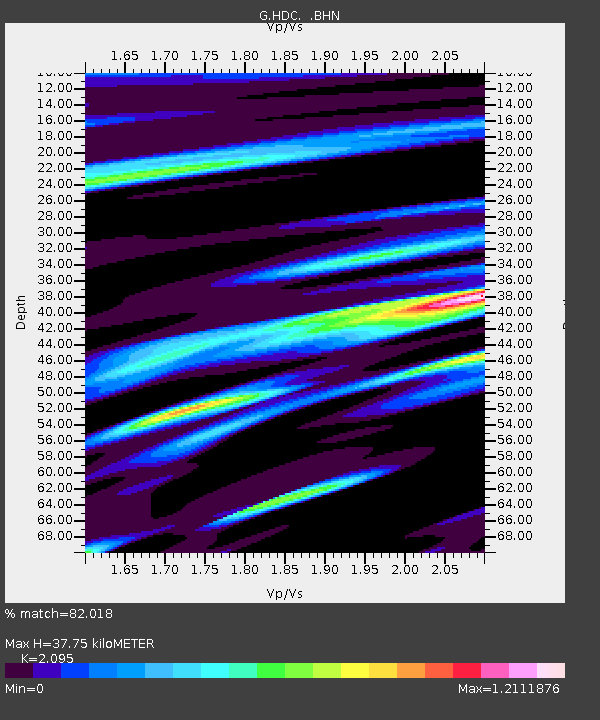
| Estimated Moho Depth: |
37.75 km |
| Estimated Crust Vp/Vs: |
2.10 |
| Assumed Crust Vp: |
6.597 km/s |
| Estimated Crust Vs: |
3.149 km/s |
| Estimated Crust Poisson's Ratio: |
0.35 |
|
| Radial Match: |
82.018 % |
| Radial Bump: |
400 |
| Transverse Match: |
78.61917 % |
| Transverse Bump: |
400 |
| SOD ConfigId: |
20082 |
| Insert Time: |
2010-02-26 22:36:35.017 +0000 |
| GWidth: |
2.5 |
| Max Bumps: |
400 |
| Tol: |
0.001 |
|

Signal To Noise
| Channel | StoN | STA | LTA |
| G:HDC: :BHN:20020328T05:02:33.133002Z | 9.563605 | 4.7584767E-6 | 4.97561E-7 |
| G:HDC: :BHE:20020328T05:02:33.133002Z | 6.4913 | 3.4432776E-6 | 5.30445E-7 |
| G:HDC: :BHZ:20020328T05:02:33.133002Z | 37.888824 | 1.0886527E-5 | 2.873282E-7 |
| Arrivals |
| Ps | 6.7 SECOND |
| PpPs | 17 SECOND |
| PsPs/PpSs | 23 SECOND |


