You are here: Home > Network List > UO - University of Oregon Regional Network Stations List
> Station BUCK Buck Mountain, OR > Earthquake Result Viewer
BUCK Buck Mountain, OR - Earthquake Result Viewer
| Earthquake location: |
Kermadec Islands Region |
| Earthquake latitude/longitude: |
-29.0/-176.2 |
| Earthquake time(UTC): |
2011/10/21 (294) 17:57:16 GMT |
| Earthquake Depth: |
33 km |
| Earthquake Magnitude: |
6.4 MB, 7.5 MS, 7.4 MW, 7.4 MW |
| Earthquake Catalog/Contributor: |
WHDF/NEIC |
|
| Network: |
UO University of Oregon Regional Network |
| Station: |
BUCK Buck Mountain, OR |
| Lat/Lon: |
44.20 N/122.99 W |
| Elevation: |
964 m |
|
| Distance: |
87.6 deg |
| Az: |
35.229 deg |
| Baz: |
224.634 deg |
| Ray Param: |
0.043171838 |
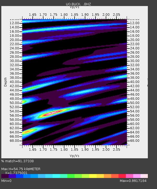
| Estimated Moho Depth: |
54.75 km |
| Estimated Crust Vp/Vs: |
1.74 |
| Assumed Crust Vp: |
6.566 km/s |
| Estimated Crust Vs: |
3.779 km/s |
| Estimated Crust Poisson's Ratio: |
0.25 |
|
| Radial Match: |
91.37338 % |
| Radial Bump: |
400 |
| Transverse Match: |
80.057755 % |
| Transverse Bump: |
400 |
| SOD ConfigId: |
424168 |
| Insert Time: |
2012-02-10 02:38:27.450 +0000 |
| GWidth: |
2.5 |
| Max Bumps: |
400 |
| Tol: |
0.001 |
|

Signal To Noise
| Channel | StoN | STA | LTA |
| UO:BUCK: :BHZ:20111021T18:09:29.654993Z | 27.765057 | 7.497618E-6 | 2.7003793E-7 |
| UO:BUCK: :BHN:20111021T18:09:29.654993Z | 13.309382 | 2.142346E-6 | 1.609651E-7 |
| UO:BUCK: :BHE:20111021T18:09:29.654993Z | 3.9253595 | 1.0746197E-6 | 2.737634E-7 |
| Arrivals |
| Ps | 6.3 SECOND |
| PpPs | 22 SECOND |
| PsPs/PpSs | 29 SECOND |


