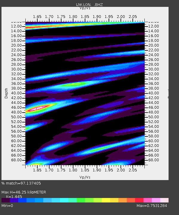
LON Longmire (broad-band and DWWSSN) - Earthquake Result Viewer
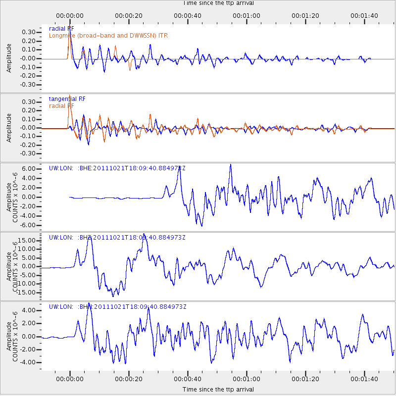
Earthquake location: Kermadec Islands Region
Earthquake latitude/longitude: -29.0/-176.2
Earthquake time(UTC): 2011/10/21 (294) 17:57:16 GMT
Earthquake Depth: 33 km
Earthquake Magnitude: 6.4 MB, 7.5 MS, 7.4 MW, 7.4 MW
Earthquake Catalog/Contributor: WHDF/NEIC
Network: UW Pacific Northwest Regional Seismic Network
Station: LON Longmire (broad-band and DWWSSN)
Lat/Lon: 46.75 N/121.81 W
Elevation: 850 m
Distance: 90.0 deg
Az: 34.007 deg
Baz: 225.444 deg
Ray Param: 0.041701887
Estimated Moho Depth: 46.25 km
Estimated Crust Vp/Vs: 1.64
Assumed Crust Vp: 6.597 km/s
Estimated Crust Vs: 4.011 km/s
Estimated Crust Poisson's Ratio: 0.21
Radial Match: 97.137405 %
Radial Bump: 400
Transverse Match: 89.76137 %
Transverse Bump: 400
SOD ConfigId: 424168
Insert Time: 2012-02-10 02:39:23.756 +0000
GWidth: 2.5
Max Bumps: 400
Tol: 0.001

Signal To Noise

ChannelStoNSTALTA
UW:LON: :BHZ:20111021T18:09:40.884973Z34.166524.074659E-61.1925883E-7
UW:LON: :BHN:20111021T18:09:40.884973Z14.55997859.865728E-76.775922E-8
UW:LON: :BHE:20111021T18:09:40.884973Z12.46038151.045466E-68.39032E-8
Arrivals
Ps4.6 SECOND
PpPs18 SECOND
PsPs/PpSs23 SECOND