You are here: Home > Network List > UW - Pacific Northwest Regional Seismic Network Stations List
> Station YACT Amboy, WA, USA > Earthquake Result Viewer
YACT Amboy, WA, USA - Earthquake Result Viewer
| Earthquake location: |
Kermadec Islands Region |
| Earthquake latitude/longitude: |
-29.0/-176.2 |
| Earthquake time(UTC): |
2011/10/21 (294) 17:57:16 GMT |
| Earthquake Depth: |
33 km |
| Earthquake Magnitude: |
6.4 MB, 7.5 MS, 7.4 MW, 7.4 MW |
| Earthquake Catalog/Contributor: |
WHDF/NEIC |
|
| Network: |
UW Pacific Northwest Regional Seismic Network |
| Station: |
YACT Amboy, WA, USA |
| Lat/Lon: |
45.93 N/122.42 W |
| Elevation: |
211 m |
|
| Distance: |
89.1 deg |
| Az: |
34.291 deg |
| Baz: |
225.007 deg |
| Ray Param: |
0.04205049 |
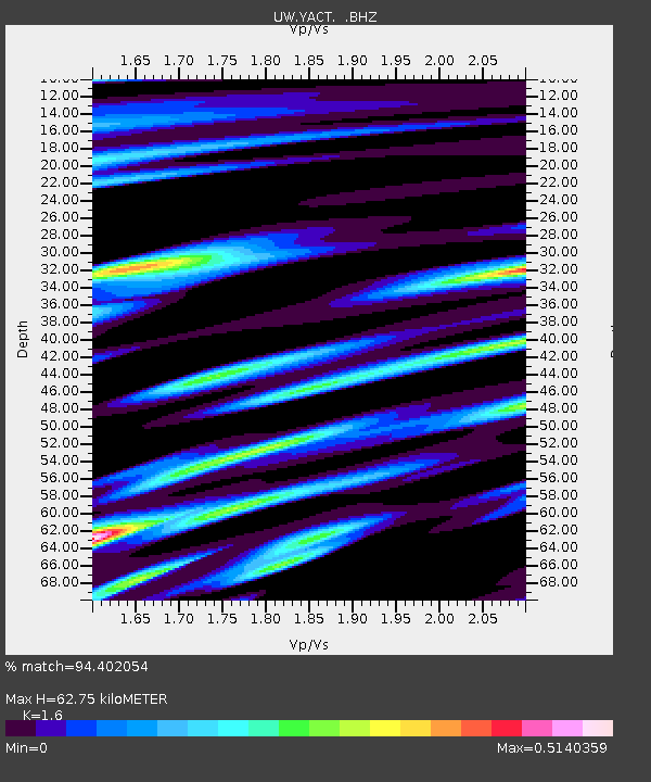
| Estimated Moho Depth: |
62.75 km |
| Estimated Crust Vp/Vs: |
1.60 |
| Assumed Crust Vp: |
6.566 km/s |
| Estimated Crust Vs: |
4.104 km/s |
| Estimated Crust Poisson's Ratio: |
0.18 |
|
| Radial Match: |
94.402054 % |
| Radial Bump: |
400 |
| Transverse Match: |
87.20985 % |
| Transverse Bump: |
400 |
| SOD ConfigId: |
424168 |
| Insert Time: |
2012-02-10 02:39:58.777 +0000 |
| GWidth: |
2.5 |
| Max Bumps: |
400 |
| Tol: |
0.001 |
|

Signal To Noise
| Channel | StoN | STA | LTA |
| UW:YACT: :BHZ:20111021T18:09:36.800012Z | 39.93139 | 5.8819132E-6 | 1.473005E-7 |
| UW:YACT: :BHN:20111021T18:09:36.800012Z | 17.392784 | 1.4809731E-6 | 8.5148706E-8 |
| UW:YACT: :BHE:20111021T18:09:36.800012Z | 8.203823 | 1.0050413E-6 | 1.225089E-7 |
| Arrivals |
| Ps | 5.9 SECOND |
| PpPs | 24 SECOND |
| PsPs/PpSs | 30 SECOND |


