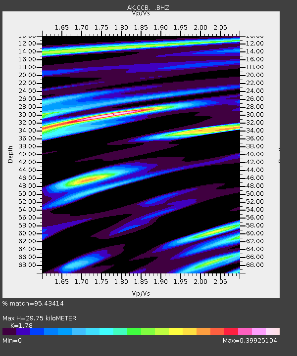
CCB Clear Creek Butte - Earthquake Result Viewer

Earthquake location: Turkey
Earthquake latitude/longitude: 38.7/43.5
Earthquake time(UTC): 2011/10/23 (296) 10:41:22 GMT
Earthquake Depth: 16 km
Earthquake Magnitude: 6.9 MB, 7.3 MS, 7.3 MW, 7.1 MW
Earthquake Catalog/Contributor: WHDF/NEIC
Network: AK Alaska Regional Network
Station: CCB Clear Creek Butte
Lat/Lon: 64.65 N/147.80 W
Elevation: 248 m
Distance: 76.6 deg
Az: 4.983 deg
Baz: 350.921 deg
Ray Param: 0.050885208
Estimated Moho Depth: 29.75 km
Estimated Crust Vp/Vs: 1.78
Assumed Crust Vp: 6.566 km/s
Estimated Crust Vs: 3.689 km/s
Estimated Crust Poisson's Ratio: 0.27
Radial Match: 95.43414 %
Radial Bump: 283
Transverse Match: 88.07155 %
Transverse Bump: 400
SOD ConfigId: 424168
Insert Time: 2012-02-16 05:24:52.853 +0000
GWidth: 2.5
Max Bumps: 400
Tol: 0.001

Signal To Noise

ChannelStoNSTALTA
AK:CCB: :BHZ:20111023T10:52:41.148018Z86.913531.0031776E-51.1542249E-7
AK:CCB: :BHN:20111023T10:52:41.148018Z34.3596952.9009807E-68.442975E-8
AK:CCB: :BHE:20111023T10:52:41.148018Z12.1757631.5162916E-61.245336E-7
Arrivals
Ps3.7 SECOND
PpPs12 SECOND
PsPs/PpSs16 SECOND