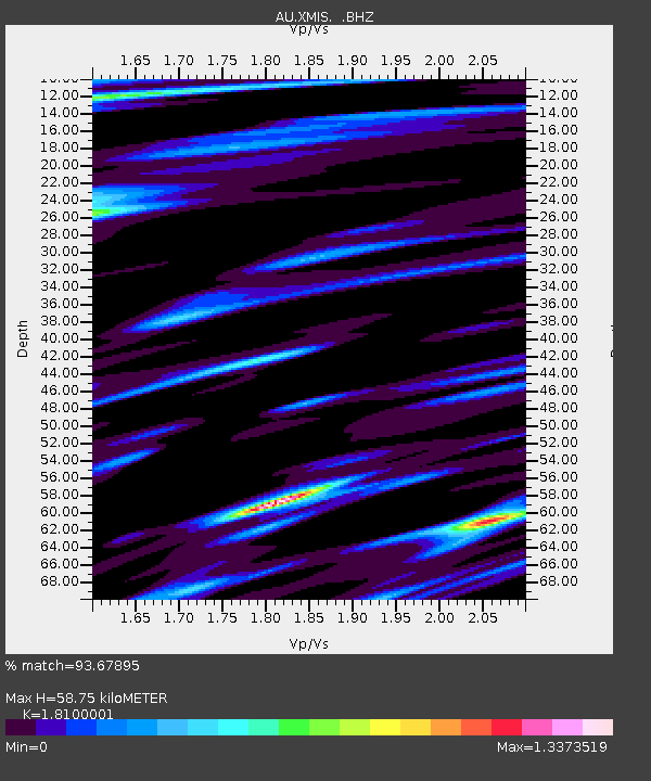
XMIS Christmas Island Grants Well - Earthquake Result Viewer

Earthquake location: Turkey
Earthquake latitude/longitude: 38.7/43.5
Earthquake time(UTC): 2011/10/23 (296) 10:41:22 GMT
Earthquake Depth: 16 km
Earthquake Magnitude: 6.9 MB, 7.3 MS, 7.3 MW, 7.1 MW
Earthquake Catalog/Contributor: WHDF/NEIC
Network: AU Australian Seismological Centre
Station: XMIS Christmas Island Grants Well
Lat/Lon: 10.48 S/105.65 E
Elevation: 210 m
Distance: 75.7 deg
Az: 116.192 deg
Baz: 314.466 deg
Ray Param: 0.051478706
Estimated Moho Depth: 58.75 km
Estimated Crust Vp/Vs: 1.81
Assumed Crust Vp: 4.157 km/s
Estimated Crust Vs: 2.297 km/s
Estimated Crust Poisson's Ratio: 0.28
Radial Match: 93.67895 %
Radial Bump: 364
Transverse Match: 86.00814 %
Transverse Bump: 400
SOD ConfigId: 424168
Insert Time: 2012-02-16 05:26:30.594 +0000
GWidth: 2.5
Max Bumps: 400
Tol: 0.001

Signal To Noise

ChannelStoNSTALTA
AU:XMIS: :BHZ:20111023T10:52:36.145027Z29.5275868.6891005E-62.9427062E-7
AU:XMIS: :BHN:20111023T10:52:36.145027Z7.414673.227342E-64.3526444E-7
AU:XMIS: :BHE:20111023T10:52:36.145027Z10.2986262.7501997E-62.670453E-7
Arrivals
Ps12 SECOND
PpPs39 SECOND
PsPs/PpSs51 SECOND