You are here: Home > Network List > TA - USArray Transportable Network (new EarthScope stations) Stations List
> Station R56A Bull Pasture Mountain, McDowell, VA, USA > Earthquake Result Viewer
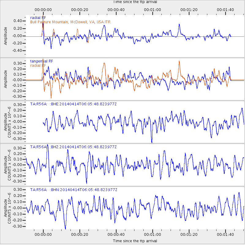
R56A Bull Pasture Mountain, McDowell, VA, USA - Earthquake Result Viewer
*The percent match for this event was below the threshold and hence no stack was calculated.
| Earthquake location: |
Near Coast Of Northern Chile |
| Earthquake latitude/longitude: |
-20.7/-70.7 |
| Earthquake time(UTC): |
2014/04/14 (104) 05:56:20 GMT |
| Earthquake Depth: |
30 km |
| Earthquake Magnitude: |
5.3 MW |
| Earthquake Catalog/Contributor: |
ISC/ISC |
|
| Network: |
TA USArray Transportable Network (new EarthScope stations) |
| Station: |
R56A Bull Pasture Mountain, McDowell, VA, USA |
| Lat/Lon: |
38.41 N/79.40 W |
| Elevation: |
902 m |
|
| Distance: |
59.4 deg |
| Az: |
352.034 deg |
| Baz: |
170.496 deg |
| Ray Param: |
$rayparam |
*The percent match for this event was below the threshold and hence was not used in the summary stack. |
|
| Radial Match: |
43.519203 % |
| Radial Bump: |
400 |
| Transverse Match: |
36.39313 % |
| Transverse Bump: |
400 |
| SOD ConfigId: |
3390531 |
| Insert Time: |
2019-04-11 09:41:21.864 +0000 |
| GWidth: |
2.5 |
| Max Bumps: |
400 |
| Tol: |
0.001 |
|
Signal To Noise
| Channel | StoN | STA | LTA |
| TA:R56A: :BHZ:20140414T06:05:48.823977Z | 2.4608963 | 1.7887643E-7 | 7.268751E-8 |
| TA:R56A: :BHN:20140414T06:05:48.823977Z | 1.1201786 | 7.706844E-8 | 6.880014E-8 |
| TA:R56A: :BHE:20140414T06:05:48.823977Z | 0.9473062 | 8.2279335E-8 | 8.685611E-8 |
| Arrivals |
| Ps | |
| PpPs | |
| PsPs/PpSs | |


