You are here: Home > Network List > IW - Intermountain West Stations List
> Station MOOW Moose Ponds, Wyoming, USA > Earthquake Result Viewer
MOOW Moose Ponds, Wyoming, USA - Earthquake Result Viewer

| Earthquake location: |
Turkey |
| Earthquake latitude/longitude: |
38.7/43.5 |
| Earthquake time(UTC): |
2011/10/23 (296) 10:41:22 GMT |
| Earthquake Depth: |
16 km |
| Earthquake Magnitude: |
6.9 MB, 7.3 MS, 7.3 MW, 7.1 MW |
| Earthquake Catalog/Contributor: |
WHDF/NEIC |
|
| Network: |
IW Intermountain West |
| Station: |
MOOW Moose Ponds, Wyoming, USA |
| Lat/Lon: |
43.75 N/110.74 W |
| Elevation: |
2128 m |
|
| Distance: |
94.7 deg |
| Az: |
341.591 deg |
| Baz: |
19.93 deg |
| Ray Param: |
0.04098385 |
| Estimated Moho Depth: |
50.0 km |
| Estimated Crust Vp/Vs: |
1.60 |
| Assumed Crust Vp: |
6.207 km/s |
| Estimated Crust Vs: |
3.879 km/s |
| Estimated Crust Poisson's Ratio: |
0.18 |
|
| Radial Match: |
97.82951 % |
| Radial Bump: |
346 |
| Transverse Match: |
94.18559 % |
| Transverse Bump: |
400 |
| SOD ConfigId: |
424168 |
| Insert Time: |
2012-02-16 05:32:44.721 +0000 |
| GWidth: |
2.5 |
| Max Bumps: |
400 |
| Tol: |
0.001 |
|
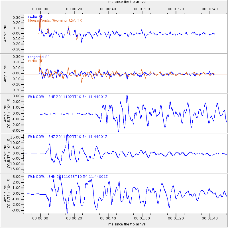
Signal To Noise
| Channel | StoN | STA | LTA |
| IW:MOOW: :BHZ:20111023T10:54:11.44001Z | 17.677555 | 1.6354576E-6 | 9.251605E-8 |
| IW:MOOW: :BHN:20111023T10:54:11.44001Z | 7.4852147 | 3.483667E-7 | 4.6540645E-8 |
| IW:MOOW: :BHE:20111023T10:54:11.44001Z | 5.5523105 | 2.3377443E-7 | 4.2103988E-8 |
| Arrivals |
| Ps | 4.9 SECOND |
| PpPs | 21 SECOND |
| PsPs/PpSs | 25 SECOND |


