You are here: Home > Network List > IW - Intermountain West Stations List
> Station DLMT Dillon, Montana, USA > Earthquake Result Viewer
DLMT Dillon, Montana, USA - Earthquake Result Viewer

| Earthquake location: |
Turkey |
| Earthquake latitude/longitude: |
38.7/43.5 |
| Earthquake time(UTC): |
2011/10/23 (296) 10:41:22 GMT |
| Earthquake Depth: |
16 km |
| Earthquake Magnitude: |
6.9 MB, 7.3 MS, 7.3 MW, 7.1 MW |
| Earthquake Catalog/Contributor: |
WHDF/NEIC |
|
| Network: |
IW Intermountain West |
| Station: |
DLMT Dillon, Montana, USA |
| Lat/Lon: |
45.36 N/112.60 W |
| Elevation: |
1569 m |
|
| Distance: |
93.6 deg |
| Az: |
343.377 deg |
| Baz: |
18.507 deg |
| Ray Param: |
0.041230395 |
| Estimated Moho Depth: |
56.5 km |
| Estimated Crust Vp/Vs: |
1.98 |
| Assumed Crust Vp: |
6.577 km/s |
| Estimated Crust Vs: |
3.326 km/s |
| Estimated Crust Poisson's Ratio: |
0.33 |
|
| Radial Match: |
89.22545 % |
| Radial Bump: |
400 |
| Transverse Match: |
82.57531 % |
| Transverse Bump: |
400 |
| SOD ConfigId: |
424168 |
| Insert Time: |
2012-02-16 05:33:29.681 +0000 |
| GWidth: |
2.5 |
| Max Bumps: |
400 |
| Tol: |
0.001 |
|
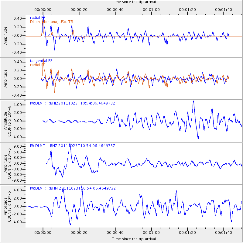
Signal To Noise
| Channel | StoN | STA | LTA |
| IW:DLMT: :BHZ:20111023T10:54:06.464973Z | 34.326458 | 2.569986E-6 | 7.486895E-8 |
| IW:DLMT: :BHN:20111023T10:54:06.464973Z | 5.9155507 | 8.7680996E-7 | 1.4822119E-7 |
| IW:DLMT: :BHE:20111023T10:54:06.464973Z | 1.9993126 | 3.8517206E-7 | 1.9265224E-7 |
| Arrivals |
| Ps | 8.6 SECOND |
| PpPs | 25 SECOND |
| PsPs/PpSs | 34 SECOND |


