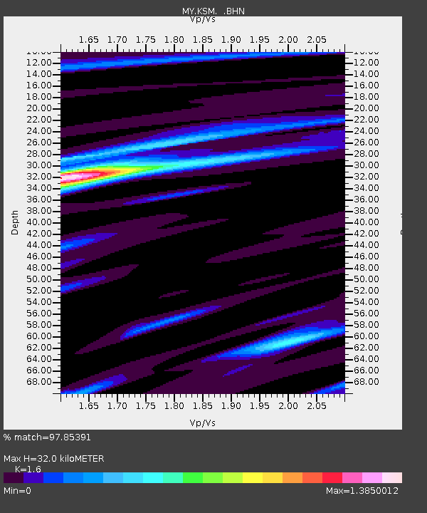
KSM Kuching - Earthquake Result Viewer

Earthquake location: Turkey
Earthquake latitude/longitude: 38.7/43.5
Earthquake time(UTC): 2011/10/23 (296) 10:41:22 GMT
Earthquake Depth: 16 km
Earthquake Magnitude: 6.9 MB, 7.3 MS, 7.3 MW, 7.1 MW
Earthquake Catalog/Contributor: WHDF/NEIC
Network: MY Malaysian National Seismic Network
Station: KSM Kuching
Lat/Lon: 1.47 N/110.31 E
Elevation: 66 m
Distance: 71.1 deg
Az: 103.784 deg
Baz: 310.54 deg
Ray Param: 0.05453633
Estimated Moho Depth: 32.0 km
Estimated Crust Vp/Vs: 1.60
Assumed Crust Vp: 6.468 km/s
Estimated Crust Vs: 4.042 km/s
Estimated Crust Poisson's Ratio: 0.18
Radial Match: 97.85391 %
Radial Bump: 400
Transverse Match: 93.62798 %
Transverse Bump: 400
SOD ConfigId: 424168
Insert Time: 2012-02-16 05:36:19.438 +0000
GWidth: 2.5
Max Bumps: 400
Tol: 0.001

Signal To Noise

ChannelStoNSTALTA
MY:KSM: :BHZ:20111023T10:52:09.070015Z154.736919.731289E-66.288926E-8
MY:KSM: :BHN:20111023T10:52:09.070015Z54.8990752.4420854E-64.448318E-8
MY:KSM: :BHE:20111023T10:52:09.070015Z66.346692.7747642E-64.1822194E-8
Arrivals
Ps3.1 SECOND
PpPs12 SECOND
PsPs/PpSs15 SECOND