You are here: Home > Network List > CI - Caltech Regional Seismic Network Stations List
> Station LGU LGU, Camarillo, CA, USA > Earthquake Result Viewer
LGU LGU, Camarillo, CA, USA - Earthquake Result Viewer
| Earthquake location: |
Fox Islands, Aleutian Islands |
| Earthquake latitude/longitude: |
52.5/-168.0 |
| Earthquake time(UTC): |
2007/07/15 (196) 13:08:00 GMT |
| Earthquake Depth: |
10 km |
| Earthquake Magnitude: |
5.8 MB, 5.9 MS, 6.1 MW, 6.0 MW |
| Earthquake Catalog/Contributor: |
WHDF/NEIC |
|
| Network: |
CI Caltech Regional Seismic Network |
| Station: |
LGU LGU, Camarillo, CA, USA |
| Lat/Lon: |
34.11 N/119.07 W |
| Elevation: |
416 m |
|
| Distance: |
39.2 deg |
| Az: |
98.13 deg |
| Baz: |
313.136 deg |
| Ray Param: |
0.07510693 |
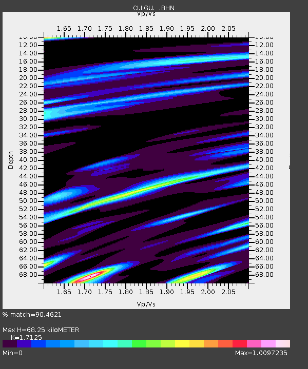
| Estimated Moho Depth: |
68.25 km |
| Estimated Crust Vp/Vs: |
1.71 |
| Assumed Crust Vp: |
6.1 km/s |
| Estimated Crust Vs: |
3.562 km/s |
| Estimated Crust Poisson's Ratio: |
0.24 |
|
| Radial Match: |
90.4621 % |
| Radial Bump: |
400 |
| Transverse Match: |
82.445465 % |
| Transverse Bump: |
400 |
| SOD ConfigId: |
2564 |
| Insert Time: |
2010-02-25 20:19:21.553 +0000 |
| GWidth: |
2.5 |
| Max Bumps: |
400 |
| Tol: |
0.001 |
|
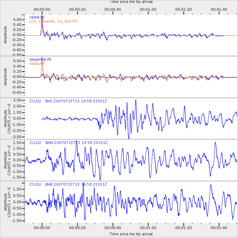
Signal To Noise
| Channel | StoN | STA | LTA |
| CI:LGU: :BHN:20070715T13:14:58.33301Z | 2.9893506 | 3.9331812E-7 | 1.315731E-7 |
| CI:LGU: :BHE:20070715T13:14:58.33301Z | 2.596563 | 3.117488E-7 | 1.200621E-7 |
| CI:LGU: :BHZ:20070715T13:14:58.33301Z | 6.0504436 | 6.678677E-7 | 1.1038326E-7 |
| Arrivals |
| Ps | 8.5 SECOND |
| PpPs | 28 SECOND |
| PsPs/PpSs | 37 SECOND |


