You are here: Home > Network List > G - GEOSCOPE Stations List
> Station HDC Heredia, Costa Rica > Earthquake Result Viewer
HDC Heredia, Costa Rica - Earthquake Result Viewer

| Earthquake location: |
Tonga Islands Region |
| Earthquake latitude/longitude: |
-23.0/-174.7 |
| Earthquake time(UTC): |
2009/03/19 (078) 18:17:40 GMT |
| Earthquake Depth: |
34 km |
| Earthquake Magnitude: |
7.0 MB, 7.6 MS, 7.6 MW, 7.6 MW |
| Earthquake Catalog/Contributor: |
WHDF/NEIC |
|
| Network: |
G GEOSCOPE |
| Station: |
HDC Heredia, Costa Rica |
| Lat/Lon: |
10.00 N/84.11 W |
| Elevation: |
1154 m |
|
| Distance: |
94.3 deg |
| Az: |
81.041 deg |
| Baz: |
247.481 deg |
| Ray Param: |
0.041050956 |
| Estimated Moho Depth: |
37.75 km |
| Estimated Crust Vp/Vs: |
2.10 |
| Assumed Crust Vp: |
6.597 km/s |
| Estimated Crust Vs: |
3.145 km/s |
| Estimated Crust Poisson's Ratio: |
0.35 |
|
| Radial Match: |
95.814835 % |
| Radial Bump: |
378 |
| Transverse Match: |
92.673996 % |
| Transverse Bump: |
400 |
| SOD ConfigId: |
2658 |
| Insert Time: |
2010-02-26 22:37:17.472 +0000 |
| GWidth: |
2.5 |
| Max Bumps: |
400 |
| Tol: |
0.001 |
|
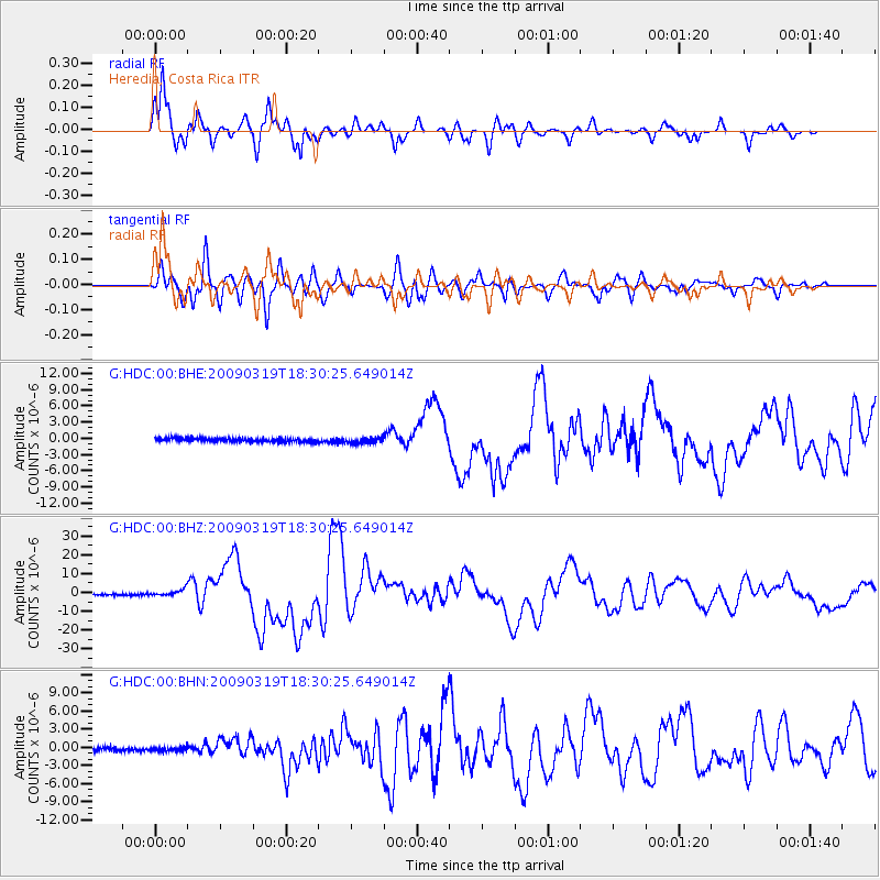
Signal To Noise
| Channel | StoN | STA | LTA |
| G:HDC:00:BHZ:20090319T18:30:25.649014Z | 4.392767 | 1.7035334E-6 | 3.878042E-7 |
| G:HDC:00:BHN:20090319T18:30:25.649014Z | 1.1873074 | 3.3975525E-7 | 2.8615608E-7 |
| G:HDC:00:BHE:20090319T18:30:25.649014Z | 1.488209 | 5.1298065E-7 | 3.4469667E-7 |
| Arrivals |
| Ps | 6.4 SECOND |
| PpPs | 17 SECOND |
| PsPs/PpSs | 24 SECOND |


