You are here: Home > Network List > TA - USArray Transportable Network (new EarthScope stations) Stations List
> Station MDND Maddock, ND, USA > Earthquake Result Viewer
MDND Maddock, ND, USA - Earthquake Result Viewer

| Earthquake location: |
Turkey |
| Earthquake latitude/longitude: |
38.7/43.5 |
| Earthquake time(UTC): |
2011/10/23 (296) 10:41:22 GMT |
| Earthquake Depth: |
16 km |
| Earthquake Magnitude: |
6.9 MB, 7.3 MS, 7.3 MW, 7.1 MW |
| Earthquake Catalog/Contributor: |
WHDF/NEIC |
|
| Network: |
TA USArray Transportable Network (new EarthScope stations) |
| Station: |
MDND Maddock, ND, USA |
| Lat/Lon: |
47.85 N/99.60 W |
| Elevation: |
479 m |
|
| Distance: |
87.8 deg |
| Az: |
336.135 deg |
| Baz: |
28.025 deg |
| Ray Param: |
0.043077596 |
| Estimated Moho Depth: |
46.0 km |
| Estimated Crust Vp/Vs: |
1.67 |
| Assumed Crust Vp: |
6.53 km/s |
| Estimated Crust Vs: |
3.905 km/s |
| Estimated Crust Poisson's Ratio: |
0.22 |
|
| Radial Match: |
96.79679 % |
| Radial Bump: |
374 |
| Transverse Match: |
93.578186 % |
| Transverse Bump: |
400 |
| SOD ConfigId: |
424168 |
| Insert Time: |
2012-02-16 05:40:15.521 +0000 |
| GWidth: |
2.5 |
| Max Bumps: |
400 |
| Tol: |
0.001 |
|
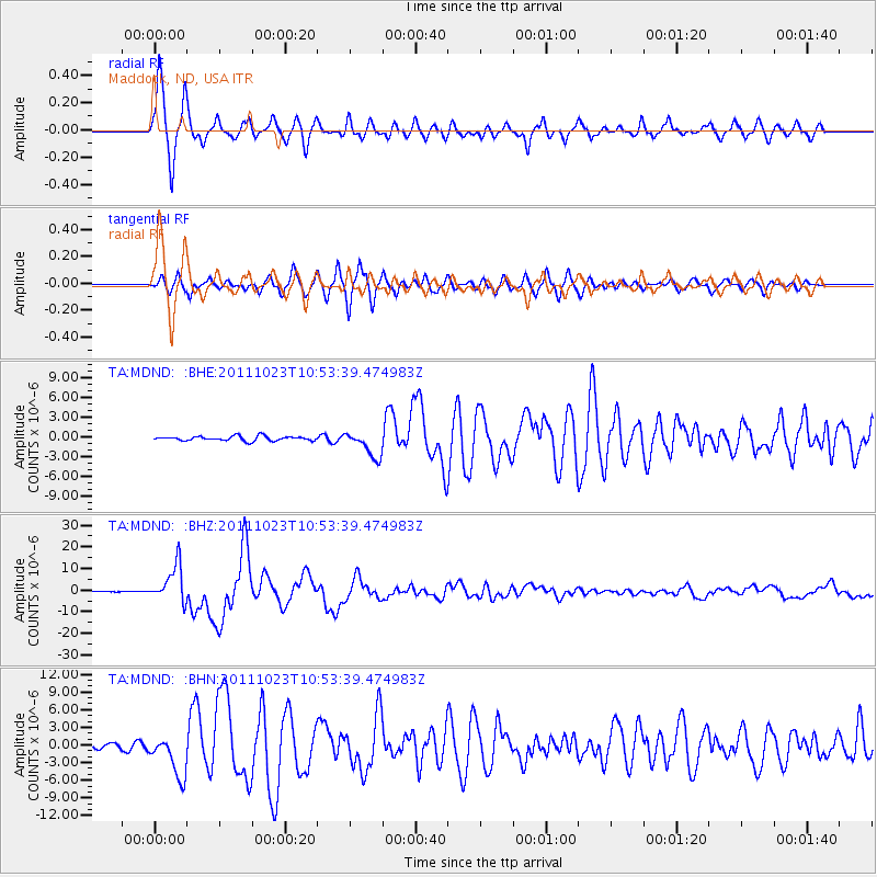
Signal To Noise
| Channel | StoN | STA | LTA |
| TA:MDND: :BHZ:20111023T10:53:39.474983Z | 61.564312 | 8.542711E-6 | 1.3876077E-7 |
| TA:MDND: :BHN:20111023T10:53:39.474983Z | 6.1097846 | 3.5480994E-6 | 5.8072413E-7 |
| TA:MDND: :BHE:20111023T10:53:39.474983Z | 5.9072943 | 1.9922486E-6 | 3.372523E-7 |
| Arrivals |
| Ps | 4.9 SECOND |
| PpPs | 18 SECOND |
| PsPs/PpSs | 23 SECOND |


