You are here: Home > Network List > CB - China National Seismic Network Stations List
> Station XLT Xilinhaote,Neimeng Province > Earthquake Result Viewer
XLT Xilinhaote,Neimeng Province - Earthquake Result Viewer
| Earthquake location: |
Solomon Islands |
| Earthquake latitude/longitude: |
-11.3/161.8 |
| Earthquake time(UTC): |
2014/04/14 (104) 06:29:50 GMT |
| Earthquake Depth: |
35 km |
| Earthquake Magnitude: |
5.9 MWP |
| Earthquake Catalog/Contributor: |
NEIC PDE/NEIC COMCAT |
|
| Network: |
CB China National Seismic Network |
| Station: |
XLT Xilinhaote,Neimeng Province |
| Lat/Lon: |
43.90 N/116.08 E |
| Elevation: |
1030 m |
|
| Distance: |
68.8 deg |
| Az: |
326.303 deg |
| Baz: |
131.16 deg |
| Ray Param: |
0.055989873 |
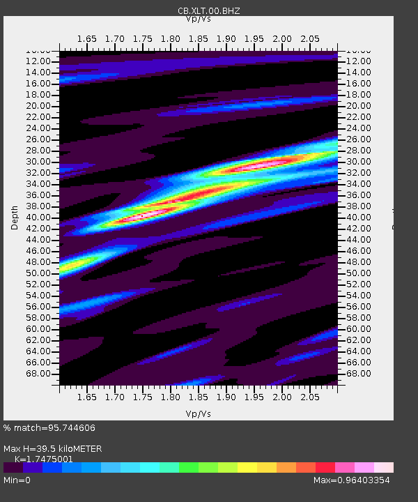
| Estimated Moho Depth: |
39.5 km |
| Estimated Crust Vp/Vs: |
1.75 |
| Assumed Crust Vp: |
6.459 km/s |
| Estimated Crust Vs: |
3.696 km/s |
| Estimated Crust Poisson's Ratio: |
0.26 |
|
| Radial Match: |
95.744606 % |
| Radial Bump: |
235 |
| Transverse Match: |
64.03742 % |
| Transverse Bump: |
400 |
| SOD ConfigId: |
3390531 |
| Insert Time: |
2019-04-11 09:45:50.912 +0000 |
| GWidth: |
2.5 |
| Max Bumps: |
400 |
| Tol: |
0.001 |
|

Signal To Noise
| Channel | StoN | STA | LTA |
| CB:XLT:00:BHZ:20140414T06:40:20.880027Z | 3.0656102 | 2.4805178E-7 | 8.091432E-8 |
| CB:XLT:00:BHN:20140414T06:40:20.880027Z | 1.1543889 | 1.0532022E-7 | 9.1234604E-8 |
| CB:XLT:00:BHE:20140414T06:40:20.880027Z | 1.7393898 | 1.3194125E-7 | 7.5854906E-8 |
| Arrivals |
| Ps | 4.8 SECOND |
| PpPs | 16 SECOND |
| PsPs/PpSs | 21 SECOND |


