You are here: Home > Network List > TA - USArray Transportable Network (new EarthScope stations) Stations List
> Station R36A Gordon, Harris, KS, USA > Earthquake Result Viewer
R36A Gordon, Harris, KS, USA - Earthquake Result Viewer
| Earthquake location: |
Turkey |
| Earthquake latitude/longitude: |
38.7/43.5 |
| Earthquake time(UTC): |
2011/10/23 (296) 10:41:22 GMT |
| Earthquake Depth: |
16 km |
| Earthquake Magnitude: |
6.9 MB, 7.3 MS, 7.3 MW, 7.1 MW |
| Earthquake Catalog/Contributor: |
WHDF/NEIC |
|
| Network: |
TA USArray Transportable Network (new EarthScope stations) |
| Station: |
R36A Gordon, Harris, KS, USA |
| Lat/Lon: |
38.32 N/95.50 W |
| Elevation: |
354 m |
|
| Distance: |
94.6 deg |
| Az: |
328.836 deg |
| Baz: |
30.974 deg |
| Ray Param: |
0.04100828 |
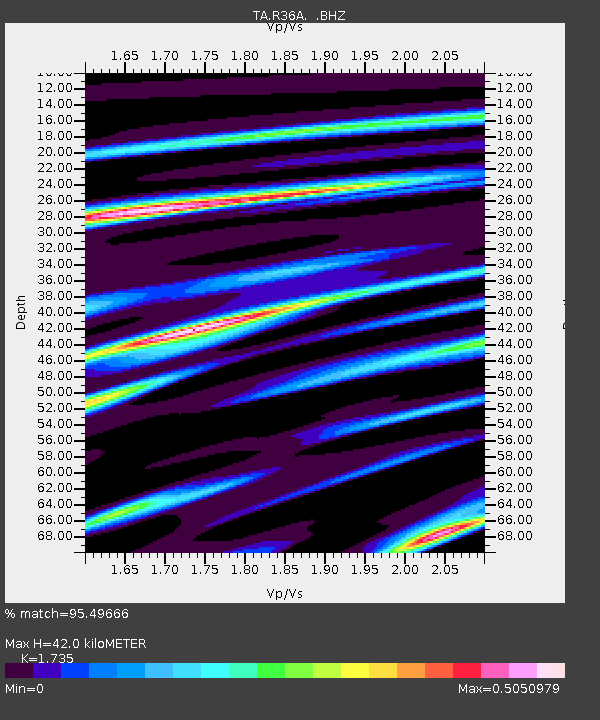
| Estimated Moho Depth: |
42.0 km |
| Estimated Crust Vp/Vs: |
1.74 |
| Assumed Crust Vp: |
6.498 km/s |
| Estimated Crust Vs: |
3.745 km/s |
| Estimated Crust Poisson's Ratio: |
0.25 |
|
| Radial Match: |
95.49666 % |
| Radial Bump: |
400 |
| Transverse Match: |
78.91359 % |
| Transverse Bump: |
400 |
| SOD ConfigId: |
424168 |
| Insert Time: |
2012-02-16 05:42:45.880 +0000 |
| GWidth: |
2.5 |
| Max Bumps: |
400 |
| Tol: |
0.001 |
|
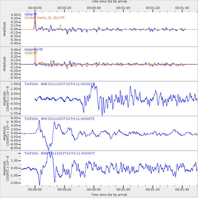
Signal To Noise
| Channel | StoN | STA | LTA |
| TA:R36A: :BHZ:20111023T10:54:11.000007Z | 24.038614 | 2.8257352E-6 | 1.1754984E-7 |
| TA:R36A: :BHN:20111023T10:54:11.000007Z | 7.260863 | 8.716542E-7 | 1.200483E-7 |
| TA:R36A: :BHE:20111023T10:54:11.000007Z | 4.7913213 | 5.570638E-7 | 1.1626518E-7 |
| Arrivals |
| Ps | 4.9 SECOND |
| PpPs | 17 SECOND |
| PsPs/PpSs | 22 SECOND |


