You are here: Home > Network List > TA - USArray Transportable Network (new EarthScope stations) Stations List
> Station W38A Poteau, OK, USA > Earthquake Result Viewer
W38A Poteau, OK, USA - Earthquake Result Viewer

| Earthquake location: |
Turkey |
| Earthquake latitude/longitude: |
38.7/43.5 |
| Earthquake time(UTC): |
2011/10/23 (296) 10:41:22 GMT |
| Earthquake Depth: |
16 km |
| Earthquake Magnitude: |
6.9 MB, 7.3 MS, 7.3 MW, 7.1 MW |
| Earthquake Catalog/Contributor: |
WHDF/NEIC |
|
| Network: |
TA USArray Transportable Network (new EarthScope stations) |
| Station: |
W38A Poteau, OK, USA |
| Lat/Lon: |
35.07 N/94.52 W |
| Elevation: |
169 m |
|
| Distance: |
96.9 deg |
| Az: |
326.457 deg |
| Baz: |
31.8 deg |
| Ray Param: |
0.040362474 |
| Estimated Moho Depth: |
18.0 km |
| Estimated Crust Vp/Vs: |
1.87 |
| Assumed Crust Vp: |
6.498 km/s |
| Estimated Crust Vs: |
3.479 km/s |
| Estimated Crust Poisson's Ratio: |
0.30 |
|
| Radial Match: |
96.57073 % |
| Radial Bump: |
400 |
| Transverse Match: |
80.44441 % |
| Transverse Bump: |
400 |
| SOD ConfigId: |
424168 |
| Insert Time: |
2012-02-16 05:43:23.663 +0000 |
| GWidth: |
2.5 |
| Max Bumps: |
400 |
| Tol: |
0.001 |
|
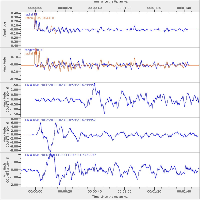
Signal To Noise
| Channel | StoN | STA | LTA |
| TA:W38A: :BHZ:20111023T10:54:21.674995Z | 23.861004 | 2.5213246E-6 | 1.0566716E-7 |
| TA:W38A: :BHN:20111023T10:54:21.674995Z | 9.086538 | 7.0762167E-7 | 7.7875825E-8 |
| TA:W38A: :BHE:20111023T10:54:21.674995Z | 3.8074248 | 4.171426E-7 | 1.0956029E-7 |
| Arrivals |
| Ps | 2.4 SECOND |
| PpPs | 7.8 SECOND |
| PsPs/PpSs | 10 SECOND |


