You are here: Home > Network List > TA - USArray Transportable Network (new EarthScope stations) Stations List
> Station Y39A Lockesburg, AR, USA > Earthquake Result Viewer
Y39A Lockesburg, AR, USA - Earthquake Result Viewer
| Earthquake location: |
Turkey |
| Earthquake latitude/longitude: |
38.7/43.5 |
| Earthquake time(UTC): |
2011/10/23 (296) 10:41:22 GMT |
| Earthquake Depth: |
16 km |
| Earthquake Magnitude: |
6.9 MB, 7.3 MS, 7.3 MW, 7.1 MW |
| Earthquake Catalog/Contributor: |
WHDF/NEIC |
|
| Network: |
TA USArray Transportable Network (new EarthScope stations) |
| Station: |
Y39A Lockesburg, AR, USA |
| Lat/Lon: |
33.94 N/94.09 W |
| Elevation: |
108 m |
|
| Distance: |
97.7 deg |
| Az: |
325.554 deg |
| Baz: |
32.154 deg |
| Ray Param: |
0.040129527 |
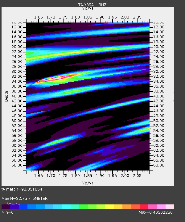
| Estimated Moho Depth: |
32.75 km |
| Estimated Crust Vp/Vs: |
1.71 |
| Assumed Crust Vp: |
6.245 km/s |
| Estimated Crust Vs: |
3.652 km/s |
| Estimated Crust Poisson's Ratio: |
0.24 |
|
| Radial Match: |
93.851654 % |
| Radial Bump: |
400 |
| Transverse Match: |
75.966995 % |
| Transverse Bump: |
400 |
| SOD ConfigId: |
424168 |
| Insert Time: |
2012-02-16 05:43:46.639 +0000 |
| GWidth: |
2.5 |
| Max Bumps: |
400 |
| Tol: |
0.001 |
|

Signal To Noise
| Channel | StoN | STA | LTA |
| TA:Y39A: :BHZ:20111023T10:54:25.125007Z | 25.263432 | 2.249286E-6 | 8.903327E-8 |
| TA:Y39A: :BHN:20111023T10:54:25.125007Z | 4.9067316 | 5.822444E-7 | 1.1866237E-7 |
| TA:Y39A: :BHE:20111023T10:54:25.125007Z | 3.4219594 | 3.9187316E-7 | 1.14517185E-7 |
| Arrivals |
| Ps | 3.8 SECOND |
| PpPs | 14 SECOND |
| PsPs/PpSs | 18 SECOND |


