You are here: Home > Network List > TA - USArray Transportable Network (new EarthScope stations) Stations List
> Station Q35A Mercer Eighty, Eskridge, KS, USA > Earthquake Result Viewer
Q35A Mercer Eighty, Eskridge, KS, USA - Earthquake Result Viewer
| Earthquake location: |
Turkey |
| Earthquake latitude/longitude: |
38.7/43.5 |
| Earthquake time(UTC): |
2011/10/23 (296) 10:41:22 GMT |
| Earthquake Depth: |
16 km |
| Earthquake Magnitude: |
6.9 MB, 7.3 MS, 7.3 MW, 7.1 MW |
| Earthquake Catalog/Contributor: |
WHDF/NEIC |
|
| Network: |
TA USArray Transportable Network (new EarthScope stations) |
| Station: |
Q35A Mercer Eighty, Eskridge, KS, USA |
| Lat/Lon: |
38.86 N/96.04 W |
| Elevation: |
402 m |
|
| Distance: |
94.3 deg |
| Az: |
329.47 deg |
| Baz: |
30.594 deg |
| Ray Param: |
0.04106595 |
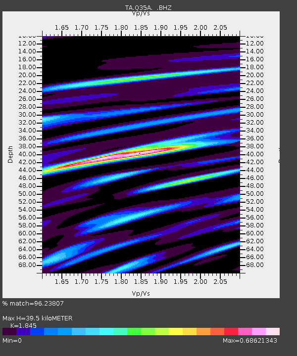
| Estimated Moho Depth: |
39.5 km |
| Estimated Crust Vp/Vs: |
1.85 |
| Assumed Crust Vp: |
6.483 km/s |
| Estimated Crust Vs: |
3.514 km/s |
| Estimated Crust Poisson's Ratio: |
0.29 |
|
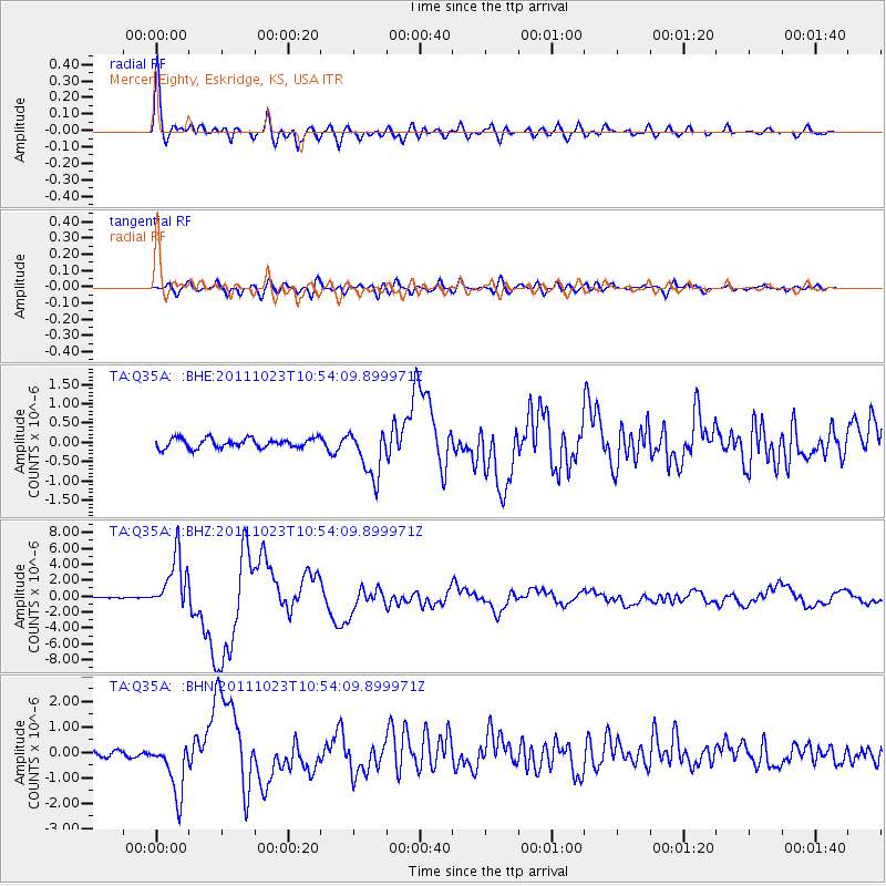
| Radial Match: |
96.23807 % |
| Radial Bump: |
400 |
| Transverse Match: |
82.354034 % |
| Transverse Bump: |
400 |
| SOD ConfigId: |
424168 |
| Insert Time: |
2012-02-16 05:44:24.201 +0000 |
| GWidth: |
2.5 |
| Max Bumps: |
400 |
| Tol: |
0.001 |
|
Signal To Noise
| Channel | StoN | STA | LTA |
| TA:Q35A: :BHZ:20111023T10:54:09.899971Z | 49.76435 | 3.467487E-6 | 6.967813E-8 |
| TA:Q35A: :BHN:20111023T10:54:09.899971Z | 12.168475 | 1.0717225E-6 | 8.807369E-8 |
| TA:Q35A: :BHE:20111023T10:54:09.899971Z | 5.0883408 | 6.2988596E-7 | 1.2379004E-7 |
| Arrivals |
| Ps | 5.3 SECOND |
| PpPs | 17 SECOND |
| PsPs/PpSs | 22 SECOND |


