You are here: Home > Network List > TA - USArray Transportable Network (new EarthScope stations) Stations List
> Station R35A Emporia Municipal Airport, Emporia, KS, USA > Earthquake Result Viewer
R35A Emporia Municipal Airport, Emporia, KS, USA - Earthquake Result Viewer
| Earthquake location: |
Turkey |
| Earthquake latitude/longitude: |
38.7/43.5 |
| Earthquake time(UTC): |
2011/10/23 (296) 10:41:22 GMT |
| Earthquake Depth: |
16 km |
| Earthquake Magnitude: |
6.9 MB, 7.3 MS, 7.3 MW, 7.1 MW |
| Earthquake Catalog/Contributor: |
WHDF/NEIC |
|
| Network: |
TA USArray Transportable Network (new EarthScope stations) |
| Station: |
R35A Emporia Municipal Airport, Emporia, KS, USA |
| Lat/Lon: |
38.32 N/96.20 W |
| Elevation: |
365 m |
|
| Distance: |
94.9 deg |
| Az: |
329.307 deg |
| Baz: |
30.507 deg |
| Ray Param: |
0.040933963 |
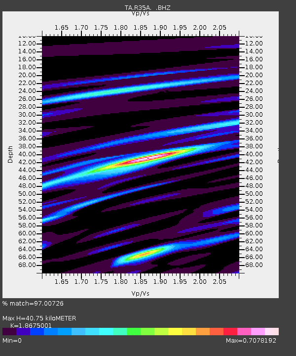
| Estimated Moho Depth: |
40.75 km |
| Estimated Crust Vp/Vs: |
1.87 |
| Assumed Crust Vp: |
6.483 km/s |
| Estimated Crust Vs: |
3.471 km/s |
| Estimated Crust Poisson's Ratio: |
0.30 |
|
| Radial Match: |
97.00726 % |
| Radial Bump: |
400 |
| Transverse Match: |
89.87637 % |
| Transverse Bump: |
400 |
| SOD ConfigId: |
424168 |
| Insert Time: |
2012-02-16 05:45:16.264 +0000 |
| GWidth: |
2.5 |
| Max Bumps: |
400 |
| Tol: |
0.001 |
|

Signal To Noise
| Channel | StoN | STA | LTA |
| TA:R35A: :BHZ:20111023T10:54:12.274971Z | 22.269938 | 3.4807729E-6 | 1.5629918E-7 |
| TA:R35A: :BHN:20111023T10:54:12.274971Z | 6.626517 | 1.0188357E-6 | 1.5375133E-7 |
| TA:R35A: :BHE:20111023T10:54:12.274971Z | 4.413087 | 6.355962E-7 | 1.4402532E-7 |
| Arrivals |
| Ps | 5.6 SECOND |
| PpPs | 18 SECOND |
| PsPs/PpSs | 23 SECOND |


