You are here: Home > Network List > TA - USArray Transportable Network (new EarthScope stations) Stations List
> Station L35A Bielow Farm, Ricketts, IA, USA > Earthquake Result Viewer
L35A Bielow Farm, Ricketts, IA, USA - Earthquake Result Viewer
| Earthquake location: |
Turkey |
| Earthquake latitude/longitude: |
38.7/43.5 |
| Earthquake time(UTC): |
2011/10/23 (296) 10:41:22 GMT |
| Earthquake Depth: |
16 km |
| Earthquake Magnitude: |
6.9 MB, 7.3 MS, 7.3 MW, 7.1 MW |
| Earthquake Catalog/Contributor: |
WHDF/NEIC |
|
| Network: |
TA USArray Transportable Network (new EarthScope stations) |
| Station: |
L35A Bielow Farm, Ricketts, IA, USA |
| Lat/Lon: |
42.11 N/95.54 W |
| Elevation: |
410 m |
|
| Distance: |
91.3 deg |
| Az: |
330.809 deg |
| Baz: |
30.846 deg |
| Ray Param: |
0.041607875 |
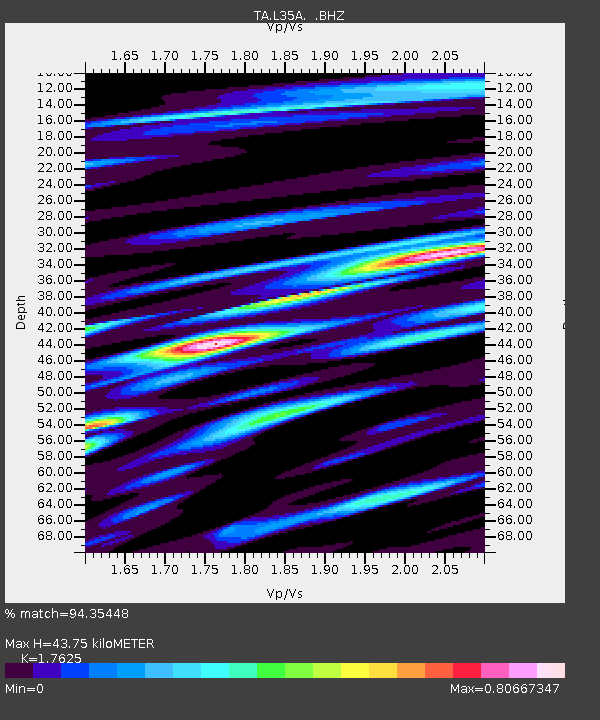
| Estimated Moho Depth: |
43.75 km |
| Estimated Crust Vp/Vs: |
1.76 |
| Assumed Crust Vp: |
6.53 km/s |
| Estimated Crust Vs: |
3.705 km/s |
| Estimated Crust Poisson's Ratio: |
0.26 |
|
| Radial Match: |
94.35448 % |
| Radial Bump: |
400 |
| Transverse Match: |
82.6427 % |
| Transverse Bump: |
400 |
| SOD ConfigId: |
424168 |
| Insert Time: |
2012-02-16 05:46:00.592 +0000 |
| GWidth: |
2.5 |
| Max Bumps: |
400 |
| Tol: |
0.001 |
|

Signal To Noise
| Channel | StoN | STA | LTA |
| TA:L35A: :BHZ:20111023T10:53:56.174995Z | 56.892254 | 6.381144E-6 | 1.1216191E-7 |
| TA:L35A: :BHN:20111023T10:53:56.174995Z | 16.85587 | 2.6821344E-6 | 1.5912168E-7 |
| TA:L35A: :BHE:20111023T10:53:56.174995Z | 13.461052 | 1.5915581E-6 | 1.18234304E-7 |
| Arrivals |
| Ps | 5.2 SECOND |
| PpPs | 18 SECOND |
| PsPs/PpSs | 23 SECOND |


