You are here: Home > Network List > TA - USArray Transportable Network (new EarthScope stations) Stations List
> Station H34A Spellman Lake, Hanley Falls, MN, USA > Earthquake Result Viewer
H34A Spellman Lake, Hanley Falls, MN, USA - Earthquake Result Viewer
| Earthquake location: |
Turkey |
| Earthquake latitude/longitude: |
38.7/43.5 |
| Earthquake time(UTC): |
2011/10/23 (296) 10:41:22 GMT |
| Earthquake Depth: |
16 km |
| Earthquake Magnitude: |
6.9 MB, 7.3 MS, 7.3 MW, 7.1 MW |
| Earthquake Catalog/Contributor: |
WHDF/NEIC |
|
| Network: |
TA USArray Transportable Network (new EarthScope stations) |
| Station: |
H34A Spellman Lake, Hanley Falls, MN, USA |
| Lat/Lon: |
44.67 N/95.78 W |
| Elevation: |
329 m |
|
| Distance: |
89.2 deg |
| Az: |
332.261 deg |
| Baz: |
30.68 deg |
| Ray Param: |
0.041988347 |
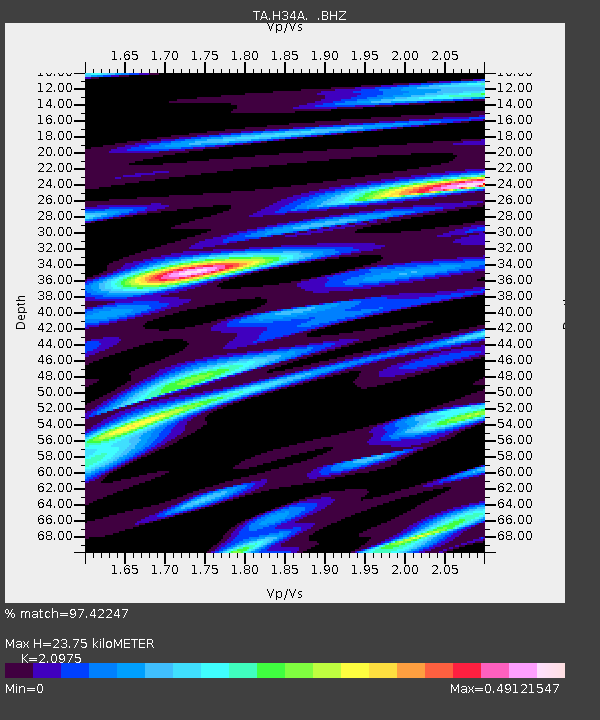
| Estimated Moho Depth: |
23.75 km |
| Estimated Crust Vp/Vs: |
2.10 |
| Assumed Crust Vp: |
6.571 km/s |
| Estimated Crust Vs: |
3.133 km/s |
| Estimated Crust Poisson's Ratio: |
0.35 |
|
| Radial Match: |
97.42247 % |
| Radial Bump: |
400 |
| Transverse Match: |
89.14713 % |
| Transverse Bump: |
400 |
| SOD ConfigId: |
424168 |
| Insert Time: |
2012-02-16 05:48:06.568 +0000 |
| GWidth: |
2.5 |
| Max Bumps: |
400 |
| Tol: |
0.001 |
|
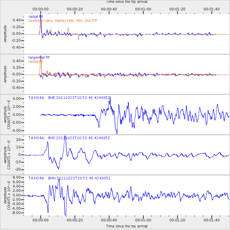
Signal To Noise
| Channel | StoN | STA | LTA |
| TA:H34A: :BHZ:20111023T10:53:46.424995Z | 46.918404 | 6.8231916E-6 | 1.4542677E-7 |
| TA:H34A: :BHN:20111023T10:53:46.424995Z | 15.597882 | 2.6293765E-6 | 1.6857265E-7 |
| TA:H34A: :BHE:20111023T10:53:46.424995Z | 14.031638 | 1.1866017E-6 | 8.456615E-8 |
| Arrivals |
| Ps | 4.0 SECOND |
| PpPs | 11 SECOND |
| PsPs/PpSs | 15 SECOND |


