You are here: Home > Network List > TA - USArray Transportable Network (new EarthScope stations) Stations List
> Station I34A Hadley, MN, USA > Earthquake Result Viewer
I34A Hadley, MN, USA - Earthquake Result Viewer
| Earthquake location: |
Turkey |
| Earthquake latitude/longitude: |
38.7/43.5 |
| Earthquake time(UTC): |
2011/10/23 (296) 10:41:22 GMT |
| Earthquake Depth: |
16 km |
| Earthquake Magnitude: |
6.9 MB, 7.3 MS, 7.3 MW, 7.1 MW |
| Earthquake Catalog/Contributor: |
WHDF/NEIC |
|
| Network: |
TA USArray Transportable Network (new EarthScope stations) |
| Station: |
I34A Hadley, MN, USA |
| Lat/Lon: |
44.04 N/95.86 W |
| Elevation: |
509 m |
|
| Distance: |
89.8 deg |
| Az: |
331.992 deg |
| Baz: |
30.62 deg |
| Ray Param: |
0.041717533 |
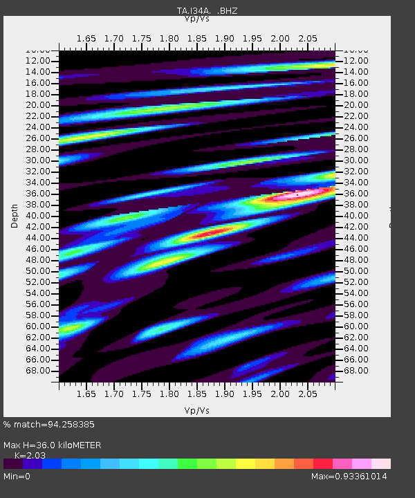
| Estimated Moho Depth: |
36.0 km |
| Estimated Crust Vp/Vs: |
2.03 |
| Assumed Crust Vp: |
6.571 km/s |
| Estimated Crust Vs: |
3.237 km/s |
| Estimated Crust Poisson's Ratio: |
0.34 |
|
| Radial Match: |
94.258385 % |
| Radial Bump: |
400 |
| Transverse Match: |
82.63029 % |
| Transverse Bump: |
400 |
| SOD ConfigId: |
424168 |
| Insert Time: |
2012-02-16 05:48:13.546 +0000 |
| GWidth: |
2.5 |
| Max Bumps: |
400 |
| Tol: |
0.001 |
|

Signal To Noise
| Channel | StoN | STA | LTA |
| TA:I34A: :BHZ:20111023T10:53:49.07502Z | 45.056183 | 6.4693418E-6 | 1.4358389E-7 |
| TA:I34A: :BHN:20111023T10:53:49.07502Z | 14.890834 | 2.3263626E-6 | 1.5622783E-7 |
| TA:I34A: :BHE:20111023T10:53:49.07502Z | 12.58342 | 1.6318122E-6 | 1.2967955E-7 |
| Arrivals |
| Ps | 5.8 SECOND |
| PpPs | 16 SECOND |
| PsPs/PpSs | 22 SECOND |


