You are here: Home > Network List > TA - USArray Transportable Network (new EarthScope stations) Stations List
> Station E32A Braaten, Kindred, ND, USA > Earthquake Result Viewer
E32A Braaten, Kindred, ND, USA - Earthquake Result Viewer

| Earthquake location: |
Turkey |
| Earthquake latitude/longitude: |
38.7/43.5 |
| Earthquake time(UTC): |
2011/10/23 (296) 10:41:22 GMT |
| Earthquake Depth: |
16 km |
| Earthquake Magnitude: |
6.9 MB, 7.3 MS, 7.3 MW, 7.1 MW |
| Earthquake Catalog/Contributor: |
WHDF/NEIC |
|
| Network: |
TA USArray Transportable Network (new EarthScope stations) |
| Station: |
E32A Braaten, Kindred, ND, USA |
| Lat/Lon: |
46.59 N/97.07 W |
| Elevation: |
297 m |
|
| Distance: |
88.0 deg |
| Az: |
334.015 deg |
| Baz: |
29.8 deg |
| Ray Param: |
0.042880956 |
| Estimated Moho Depth: |
36.5 km |
| Estimated Crust Vp/Vs: |
1.68 |
| Assumed Crust Vp: |
6.498 km/s |
| Estimated Crust Vs: |
3.873 km/s |
| Estimated Crust Poisson's Ratio: |
0.22 |
|
| Radial Match: |
94.77383 % |
| Radial Bump: |
400 |
| Transverse Match: |
77.99753 % |
| Transverse Bump: |
400 |
| SOD ConfigId: |
424168 |
| Insert Time: |
2012-02-16 05:49:40.967 +0000 |
| GWidth: |
2.5 |
| Max Bumps: |
400 |
| Tol: |
0.001 |
|
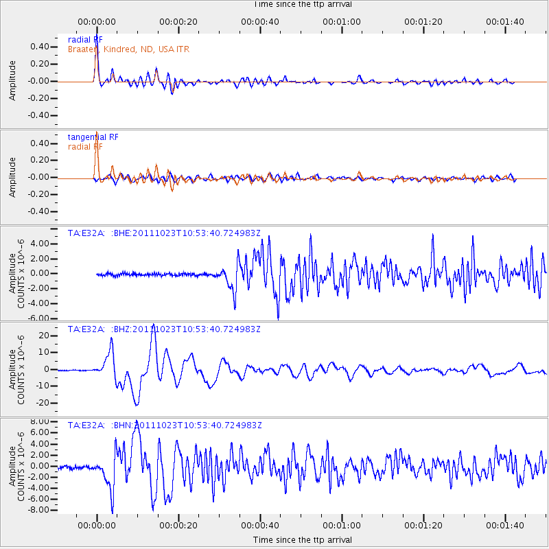
Signal To Noise
| Channel | StoN | STA | LTA |
| TA:E32A: :BHZ:20111023T10:53:40.724983Z | 41.484924 | 7.954446E-6 | 1.9174306E-7 |
| TA:E32A: :BHN:20111023T10:53:40.724983Z | 16.53712 | 3.2182022E-6 | 1.9460474E-7 |
| TA:E32A: :BHE:20111023T10:53:40.724983Z | 12.914518 | 1.7781412E-6 | 1.3768543E-7 |
| Arrivals |
| Ps | 3.9 SECOND |
| PpPs | 15 SECOND |
| PsPs/PpSs | 19 SECOND |


