You are here: Home > Network List > TA - USArray Transportable Network (new EarthScope stations) Stations List
> Station B32A Ashes, Strandquist, MN, USA > Earthquake Result Viewer
B32A Ashes, Strandquist, MN, USA - Earthquake Result Viewer
| Earthquake location: |
Turkey |
| Earthquake latitude/longitude: |
38.7/43.5 |
| Earthquake time(UTC): |
2011/10/23 (296) 10:41:22 GMT |
| Earthquake Depth: |
16 km |
| Earthquake Magnitude: |
6.9 MB, 7.3 MS, 7.3 MW, 7.1 MW |
| Earthquake Catalog/Contributor: |
WHDF/NEIC |
|
| Network: |
TA USArray Transportable Network (new EarthScope stations) |
| Station: |
B32A Ashes, Strandquist, MN, USA |
| Lat/Lon: |
48.40 N/96.54 W |
| Elevation: |
335 m |
|
| Distance: |
86.3 deg |
| Az: |
334.604 deg |
| Baz: |
30.222 deg |
| Ray Param: |
0.04415009 |
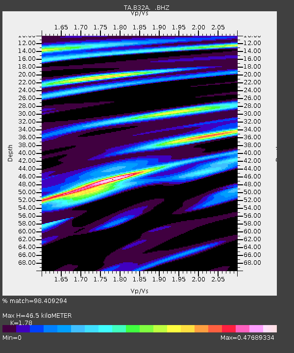
| Estimated Moho Depth: |
46.5 km |
| Estimated Crust Vp/Vs: |
1.78 |
| Assumed Crust Vp: |
6.498 km/s |
| Estimated Crust Vs: |
3.65 km/s |
| Estimated Crust Poisson's Ratio: |
0.27 |
|
| Radial Match: |
98.409294 % |
| Radial Bump: |
379 |
| Transverse Match: |
93.256584 % |
| Transverse Bump: |
400 |
| SOD ConfigId: |
424168 |
| Insert Time: |
2012-02-16 05:50:09.903 +0000 |
| GWidth: |
2.5 |
| Max Bumps: |
400 |
| Tol: |
0.001 |
|
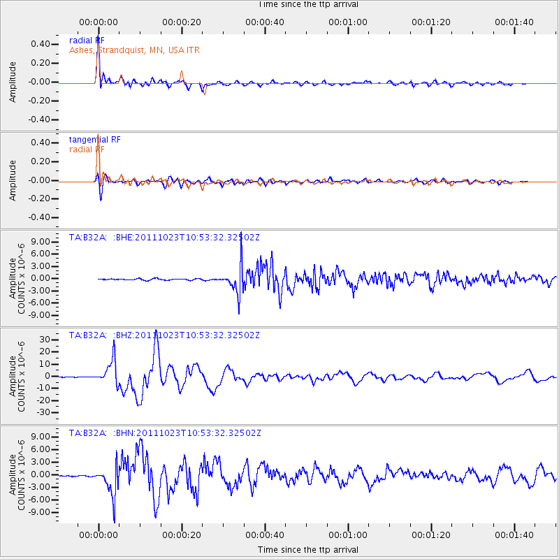
Signal To Noise
| Channel | StoN | STA | LTA |
| TA:B32A: :BHZ:20111023T10:53:32.32502Z | 113.65022 | 1.0379864E-5 | 9.1331664E-8 |
| TA:B32A: :BHN:20111023T10:53:32.32502Z | 32.261124 | 3.587172E-6 | 1.1119178E-7 |
| TA:B32A: :BHE:20111023T10:53:32.32502Z | 20.182913 | 3.3639596E-6 | 1.6667364E-7 |
| Arrivals |
| Ps | 5.7 SECOND |
| PpPs | 19 SECOND |
| PsPs/PpSs | 25 SECOND |


