You are here: Home > Network List > TA - USArray Transportable Network (new EarthScope stations) Stations List
> Station H31A Wolsey, SD, USA > Earthquake Result Viewer
H31A Wolsey, SD, USA - Earthquake Result Viewer
| Earthquake location: |
Turkey |
| Earthquake latitude/longitude: |
38.7/43.5 |
| Earthquake time(UTC): |
2011/10/23 (296) 10:41:22 GMT |
| Earthquake Depth: |
16 km |
| Earthquake Magnitude: |
6.9 MB, 7.3 MS, 7.3 MW, 7.1 MW |
| Earthquake Catalog/Contributor: |
WHDF/NEIC |
|
| Network: |
TA USArray Transportable Network (new EarthScope stations) |
| Station: |
H31A Wolsey, SD, USA |
| Lat/Lon: |
44.48 N/98.48 W |
| Elevation: |
415 m |
|
| Distance: |
90.4 deg |
| Az: |
333.843 deg |
| Baz: |
28.797 deg |
| Ray Param: |
0.041678328 |
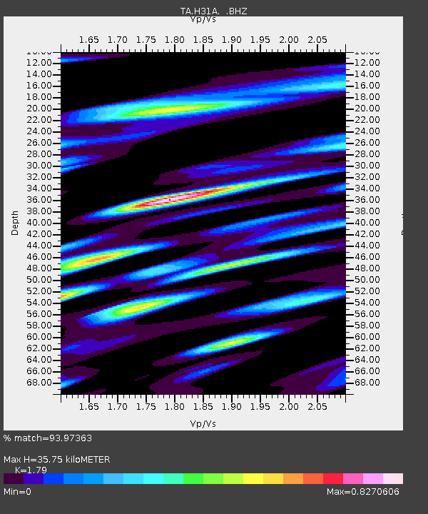
| Estimated Moho Depth: |
35.75 km |
| Estimated Crust Vp/Vs: |
1.79 |
| Assumed Crust Vp: |
6.53 km/s |
| Estimated Crust Vs: |
3.648 km/s |
| Estimated Crust Poisson's Ratio: |
0.27 |
|
| Radial Match: |
93.97363 % |
| Radial Bump: |
400 |
| Transverse Match: |
82.06682 % |
| Transverse Bump: |
400 |
| SOD ConfigId: |
424168 |
| Insert Time: |
2012-02-16 05:51:04.472 +0000 |
| GWidth: |
2.5 |
| Max Bumps: |
400 |
| Tol: |
0.001 |
|
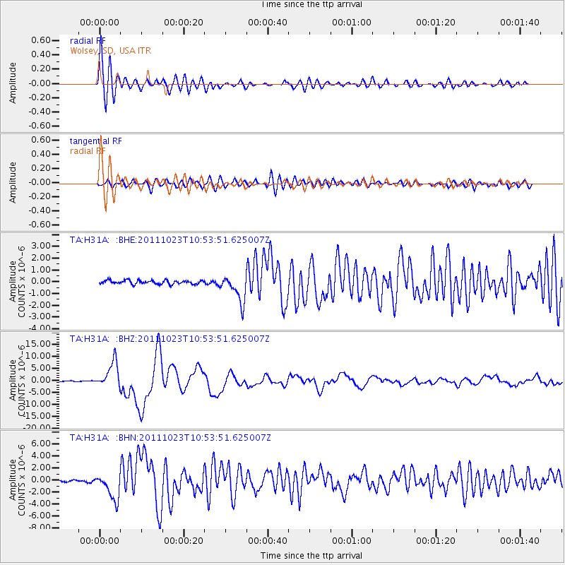
Signal To Noise
| Channel | StoN | STA | LTA |
| TA:H31A: :BHZ:20111023T10:53:51.625007Z | 36.31417 | 5.6005974E-6 | 1.5422623E-7 |
| TA:H31A: :BHN:20111023T10:53:51.625007Z | 10.896497 | 2.245045E-6 | 2.0603365E-7 |
| TA:H31A: :BHE:20111023T10:53:51.625007Z | 7.505426 | 1.1922991E-6 | 1.588583E-7 |
| Arrivals |
| Ps | 4.4 SECOND |
| PpPs | 15 SECOND |
| PsPs/PpSs | 19 SECOND |


