You are here: Home > Network List > TA - USArray Transportable Network (new EarthScope stations) Stations List
> Station G32A Webster, SD, USA > Earthquake Result Viewer
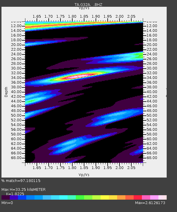
G32A Webster, SD, USA - Earthquake Result Viewer
| Earthquake location: |
Turkey |
| Earthquake latitude/longitude: |
38.7/43.5 |
| Earthquake time(UTC): |
2011/10/23 (296) 10:41:22 GMT |
| Earthquake Depth: |
16 km |
| Earthquake Magnitude: |
6.9 MB, 7.3 MS, 7.3 MW, 7.1 MW |
| Earthquake Catalog/Contributor: |
WHDF/NEIC |
|
| Network: |
TA USArray Transportable Network (new EarthScope stations) |
| Station: |
G32A Webster, SD, USA |
| Lat/Lon: |
45.26 N/97.50 W |
| Elevation: |
566 m |
|
| Distance: |
89.3 deg |
| Az: |
333.614 deg |
| Baz: |
29.484 deg |
| Ray Param: |
0.041912537 |
| Estimated Moho Depth: |
33.25 km |
| Estimated Crust Vp/Vs: |
1.82 |
| Assumed Crust Vp: |
6.552 km/s |
| Estimated Crust Vs: |
3.595 km/s |
| Estimated Crust Poisson's Ratio: |
0.28 |
|
| Radial Match: |
97.180115 % |
| Radial Bump: |
348 |
| Transverse Match: |
92.61761 % |
| Transverse Bump: |
381 |
| SOD ConfigId: |
424168 |
| Insert Time: |
2012-02-16 05:52:34.138 +0000 |
| GWidth: |
2.5 |
| Max Bumps: |
400 |
| Tol: |
0.001 |
|

Signal To Noise
| Channel | StoN | STA | LTA |
| TA:G32A: :BHZ:20111023T10:53:46.899971Z | 47.25139 | 7.3790316E-6 | 1.5616538E-7 |
| TA:G32A: :BHN:20111023T10:53:46.899971Z | 6.7395353 | 2.9202556E-6 | 4.3330223E-7 |
| TA:G32A: :BHE:20111023T10:53:46.899971Z | 2.751224 | 1.6073059E-6 | 5.8421483E-7 |
| Arrivals |
| Ps | 4.3 SECOND |
| PpPs | 14 SECOND |
| PsPs/PpSs | 18 SECOND |


