You are here: Home > Network List > TA - USArray Transportable Network (new EarthScope stations) Stations List
> Station C38A Sawbill Landing (USFS), Superior Nat. Forest, MN, > Earthquake Result Viewer
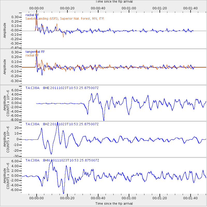
C38A Sawbill Landing (USFS), Superior Nat. Forest, MN, - Earthquake Result Viewer
*The percent match for this event was below the threshold and hence no stack was calculated.
| Earthquake location: |
Turkey |
| Earthquake latitude/longitude: |
38.7/43.5 |
| Earthquake time(UTC): |
2011/10/23 (296) 10:41:22 GMT |
| Earthquake Depth: |
16 km |
| Earthquake Magnitude: |
6.9 MB, 7.3 MS, 7.3 MW, 7.1 MW |
| Earthquake Catalog/Contributor: |
WHDF/NEIC |
|
| Network: |
TA USArray Transportable Network (new EarthScope stations) |
| Station: |
C38A Sawbill Landing (USFS), Superior Nat. Forest, MN, |
| Lat/Lon: |
47.72 N/91.27 W |
| Elevation: |
498 m |
|
| Distance: |
85.0 deg |
| Az: |
331.243 deg |
| Baz: |
33.87 deg |
| Ray Param: |
$rayparam |
*The percent match for this event was below the threshold and hence was not used in the summary stack. |
|
| Radial Match: |
96.122025 % |
| Radial Bump: |
400 |
| Transverse Match: |
93.9654 % |
| Transverse Bump: |
400 |
| SOD ConfigId: |
424168 |
| Insert Time: |
2012-02-16 05:54:16.744 +0000 |
| GWidth: |
2.5 |
| Max Bumps: |
400 |
| Tol: |
0.001 |
|
Signal To Noise
| Channel | StoN | STA | LTA |
| TA:C38A: :BHZ:20111023T10:53:25.875007Z | 53.975143 | 8.687777E-6 | 1.6095885E-7 |
| TA:C38A: :BHN:20111023T10:53:25.875007Z | 15.014193 | 1.7613283E-6 | 1.173109E-7 |
| TA:C38A: :BHE:20111023T10:53:25.875007Z | 23.0402 | 2.0851103E-6 | 9.0498794E-8 |
| Arrivals |
| Ps | |
| PpPs | |
| PsPs/PpSs | |


