You are here: Home > Network List > TA - USArray Transportable Network (new EarthScope stations) Stations List
> Station E37A Wrenshall, MN, USA > Earthquake Result Viewer
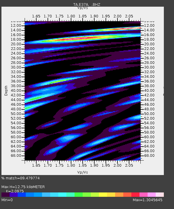
E37A Wrenshall, MN, USA - Earthquake Result Viewer
| Earthquake location: |
Turkey |
| Earthquake latitude/longitude: |
38.7/43.5 |
| Earthquake time(UTC): |
2011/10/23 (296) 10:41:22 GMT |
| Earthquake Depth: |
16 km |
| Earthquake Magnitude: |
6.9 MB, 7.3 MS, 7.3 MW, 7.1 MW |
| Earthquake Catalog/Contributor: |
WHDF/NEIC |
|
| Network: |
TA USArray Transportable Network (new EarthScope stations) |
| Station: |
E37A Wrenshall, MN, USA |
| Lat/Lon: |
46.57 N/92.40 W |
| Elevation: |
304 m |
|
| Distance: |
86.4 deg |
| Az: |
331.249 deg |
| Baz: |
33.047 deg |
| Ray Param: |
0.04408906 |
| Estimated Moho Depth: |
12.75 km |
| Estimated Crust Vp/Vs: |
2.10 |
| Assumed Crust Vp: |
6.571 km/s |
| Estimated Crust Vs: |
3.133 km/s |
| Estimated Crust Poisson's Ratio: |
0.35 |
|
| Radial Match: |
89.479774 % |
| Radial Bump: |
400 |
| Transverse Match: |
74.81601 % |
| Transverse Bump: |
400 |
| SOD ConfigId: |
424168 |
| Insert Time: |
2012-02-16 05:55:34.507 +0000 |
| GWidth: |
2.5 |
| Max Bumps: |
400 |
| Tol: |
0.001 |
|

Signal To Noise
| Channel | StoN | STA | LTA |
| TA:E37A: :BHZ:20111023T10:53:32.750007Z | 59.46204 | 1.2234908E-5 | 2.0575999E-7 |
| TA:E37A: :BHN:20111023T10:53:32.750007Z | 12.819541 | 3.9819897E-6 | 3.1061876E-7 |
| TA:E37A: :BHE:20111023T10:53:32.750007Z | 10.093733 | 3.2108596E-6 | 3.1810427E-7 |
| Arrivals |
| Ps | 2.2 SECOND |
| PpPs | 5.9 SECOND |
| PsPs/PpSs | 8.1 SECOND |


