You are here: Home > Network List > TA - USArray Transportable Network (new EarthScope stations) Stations List
> Station C34A RKJ Ranch, Bemidji, MN, USA > Earthquake Result Viewer
C34A RKJ Ranch, Bemidji, MN, USA - Earthquake Result Viewer

| Earthquake location: |
Turkey |
| Earthquake latitude/longitude: |
38.7/43.5 |
| Earthquake time(UTC): |
2011/10/23 (296) 10:41:22 GMT |
| Earthquake Depth: |
16 km |
| Earthquake Magnitude: |
6.9 MB, 7.3 MS, 7.3 MW, 7.1 MW |
| Earthquake Catalog/Contributor: |
WHDF/NEIC |
|
| Network: |
TA USArray Transportable Network (new EarthScope stations) |
| Station: |
C34A RKJ Ranch, Bemidji, MN, USA |
| Lat/Lon: |
47.65 N/94.91 W |
| Elevation: |
441 m |
|
| Distance: |
86.4 deg |
| Az: |
333.282 deg |
| Baz: |
31.342 deg |
| Ray Param: |
0.044092 |
| Estimated Moho Depth: |
44.0 km |
| Estimated Crust Vp/Vs: |
1.63 |
| Assumed Crust Vp: |
6.419 km/s |
| Estimated Crust Vs: |
3.944 km/s |
| Estimated Crust Poisson's Ratio: |
0.20 |
|
| Radial Match: |
86.443375 % |
| Radial Bump: |
400 |
| Transverse Match: |
74.0378 % |
| Transverse Bump: |
400 |
| SOD ConfigId: |
424168 |
| Insert Time: |
2012-02-16 05:55:50.634 +0000 |
| GWidth: |
2.5 |
| Max Bumps: |
400 |
| Tol: |
0.001 |
|
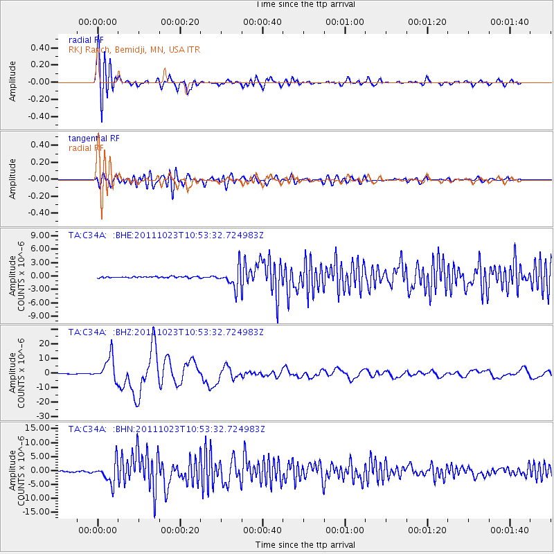
Signal To Noise
| Channel | StoN | STA | LTA |
| TA:C34A: :BHZ:20111023T10:53:32.724983Z | 47.054424 | 8.658385E-6 | 1.8400787E-7 |
| TA:C34A: :BHN:20111023T10:53:32.724983Z | 22.77831 | 3.8863263E-6 | 1.7061521E-7 |
| TA:C34A: :BHE:20111023T10:53:32.724983Z | 17.042198 | 2.3045088E-6 | 1.3522369E-7 |
| Arrivals |
| Ps | 4.4 SECOND |
| PpPs | 18 SECOND |
| PsPs/PpSs | 22 SECOND |


