You are here: Home > Network List > TA - USArray Transportable Network (new EarthScope stations) Stations List
> Station C32A Crookston, MN, USA > Earthquake Result Viewer
C32A Crookston, MN, USA - Earthquake Result Viewer

| Earthquake location: |
Turkey |
| Earthquake latitude/longitude: |
38.7/43.5 |
| Earthquake time(UTC): |
2011/10/23 (296) 10:41:22 GMT |
| Earthquake Depth: |
16 km |
| Earthquake Magnitude: |
6.9 MB, 7.3 MS, 7.3 MW, 7.1 MW |
| Earthquake Catalog/Contributor: |
WHDF/NEIC |
|
| Network: |
TA USArray Transportable Network (new EarthScope stations) |
| Station: |
C32A Crookston, MN, USA |
| Lat/Lon: |
47.83 N/96.53 W |
| Elevation: |
286 m |
|
| Distance: |
86.8 deg |
| Az: |
334.312 deg |
| Baz: |
30.21 deg |
| Ray Param: |
0.043795608 |
| Estimated Moho Depth: |
30.0 km |
| Estimated Crust Vp/Vs: |
2.01 |
| Assumed Crust Vp: |
6.498 km/s |
| Estimated Crust Vs: |
3.237 km/s |
| Estimated Crust Poisson's Ratio: |
0.33 |
|
| Radial Match: |
92.41287 % |
| Radial Bump: |
400 |
| Transverse Match: |
71.44435 % |
| Transverse Bump: |
400 |
| SOD ConfigId: |
424168 |
| Insert Time: |
2012-02-16 05:56:10.622 +0000 |
| GWidth: |
2.5 |
| Max Bumps: |
400 |
| Tol: |
0.001 |
|
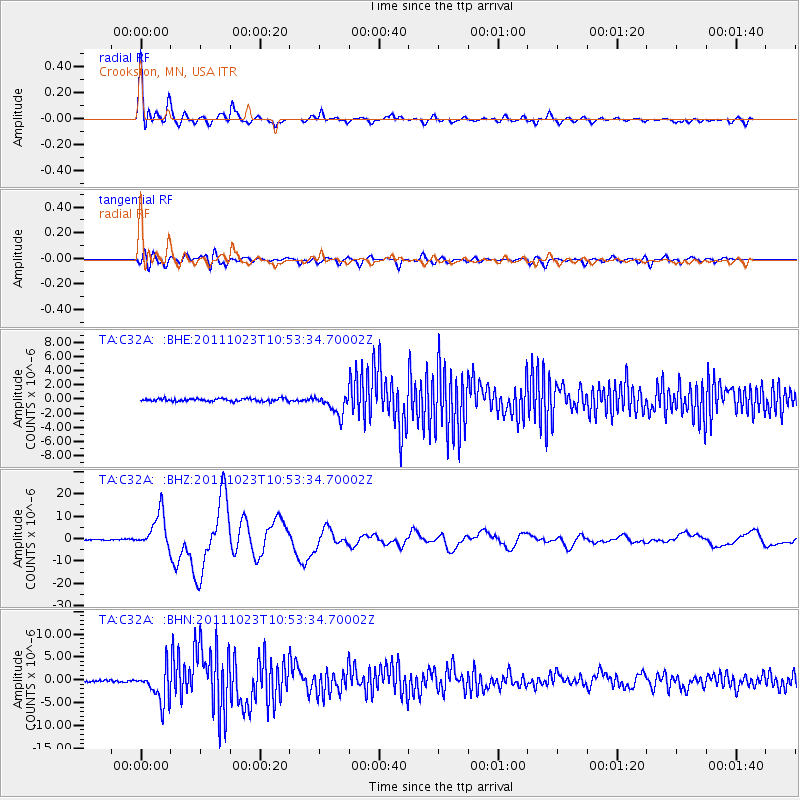
Signal To Noise
| Channel | StoN | STA | LTA |
| TA:C32A: :BHZ:20111023T10:53:34.70002Z | 45.224922 | 7.956355E-6 | 1.7592855E-7 |
| TA:C32A: :BHN:20111023T10:53:34.70002Z | 21.397982 | 3.660171E-6 | 1.7105215E-7 |
| TA:C32A: :BHE:20111023T10:53:34.70002Z | 7.5228915 | 1.4477513E-6 | 1.9244612E-7 |
| Arrivals |
| Ps | 4.7 SECOND |
| PpPs | 14 SECOND |
| PsPs/PpSs | 18 SECOND |


