You are here: Home > Network List > TA - USArray Transportable Network (new EarthScope stations) Stations List
> Station N37A Lee Faris, Mount Ayr, IA, USA > Earthquake Result Viewer
N37A Lee Faris, Mount Ayr, IA, USA - Earthquake Result Viewer
| Earthquake location: |
Turkey |
| Earthquake latitude/longitude: |
38.7/43.5 |
| Earthquake time(UTC): |
2011/10/23 (296) 10:41:22 GMT |
| Earthquake Depth: |
16 km |
| Earthquake Magnitude: |
6.9 MB, 7.3 MS, 7.3 MW, 7.1 MW |
| Earthquake Catalog/Contributor: |
WHDF/NEIC |
|
| Network: |
TA USArray Transportable Network (new EarthScope stations) |
| Station: |
N37A Lee Faris, Mount Ayr, IA, USA |
| Lat/Lon: |
40.76 N/94.21 W |
| Elevation: |
351 m |
|
| Distance: |
92.0 deg |
| Az: |
329.248 deg |
| Baz: |
31.772 deg |
| Ray Param: |
0.04152601 |
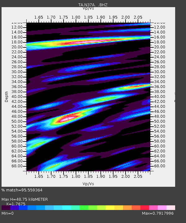
| Estimated Moho Depth: |
48.75 km |
| Estimated Crust Vp/Vs: |
1.77 |
| Assumed Crust Vp: |
6.498 km/s |
| Estimated Crust Vs: |
3.676 km/s |
| Estimated Crust Poisson's Ratio: |
0.26 |
|
| Radial Match: |
95.559364 % |
| Radial Bump: |
400 |
| Transverse Match: |
86.47348 % |
| Transverse Bump: |
400 |
| SOD ConfigId: |
424168 |
| Insert Time: |
2012-02-16 05:56:24.837 +0000 |
| GWidth: |
2.5 |
| Max Bumps: |
400 |
| Tol: |
0.001 |
|

Signal To Noise
| Channel | StoN | STA | LTA |
| TA:N37A: :BHZ:20111023T10:53:59.125007Z | 37.45614 | 5.1993065E-6 | 1.3881053E-7 |
| TA:N37A: :BHN:20111023T10:53:59.125007Z | 15.92324 | 1.8205684E-6 | 1.14334036E-7 |
| TA:N37A: :BHE:20111023T10:53:59.125007Z | 10.103036 | 1.1755004E-6 | 1.1635121E-7 |
| Arrivals |
| Ps | 5.9 SECOND |
| PpPs | 20 SECOND |
| PsPs/PpSs | 26 SECOND |


